Nuquí geodata
Nuquí (Chocó) is a seat of a second-order administrative division; located in Colombia in America/Bogota (GMT-5) time zone. With population of 2,741 people, there are 708 cities with bigger population in this country. Compared to other cities in Colombia, 54.1% of cities are located further ↓South; 94.5% of cities are located further →East and 97.1% of cities have higher elevation than Nuquí. Note1


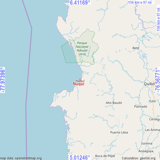
Nuquí GPS coordinates[2]
5° 42' 45" North, 77° 16' 14.988" West
| Map corner | latitude | longitude |
|---|---|---|
| Upper-left | 6.41169°, | -77.97396° |
| Center: | 5.7125°, | -77.27083° |
| Lower-right: | 5.01246°, | -76.56771° |
| Map W x H: | 155.6×155.6 km | = 96.7×96.7mi |
| max Lat: | 13.38166° ⇑45.9% North |
| Nuquí: | 5.7125° |
| min Lat: | ⇓54.1% South -4.21528° |
| min Long | Nuquí | max Long |
| -81.70636° | -77.27083° | -67.06996° |
| W 5.5%⇐ | ⇒94.5% E |
Elevation
Elevation of Nuquí is 9 m = 30 ft, and this is 1140.3 m = 3741 ft below average elevation for this country.
| Max E: |
3342 m = 10965 ft | 97.1% |
| Avg. | 1149.3 m = 3771 ft | |
| Nuquí | 9 m = 30 ft | |
Min E: |
1 m = 3 ft | 2.9% |
See also: Colombia elevation on elevation.city.
Geographical zone
Nuquí is located in North Torrid zone (between Equator and Tropic of Cancer). Distance of Equator is 635.2 km =394.7 mi to South.| Distance of | km | miles | from Nuquí |
|---|---|---|---|
| North Pole | 9371.9 | 5823.4 | to North |
| Arctic Circle | 6766 | 4204.2 | to North |
| Tropic Cancer | 1970.7 | 1224.5 | to North |
| Equator | 635.2 | 394.7 | to South |


Nearby cities:
15 places around Nuquí: (largest is in red/bold)
• Bahía Solano
59 km =36.7 mi,  345°
345°
• Beté
62.6 km =38.9 mi,  59°
59°
• Cértegui
83 km =51.6 mi,  117°
117°
• El Cantón de San Pablo
72.7 km =45.2 mi, 124°
• Istmina
89.4 km =55.6 mi,  133°
133°
• Lloró
83.4 km =51.8 mi,  106°
106°
• Managrú
73.2 km =45.5 mi, 124°
• Paimadó
64 km =39.8 mi, 113°
• Pie de Pató
39.4 km =24.5 mi, 123°
• Pizarro
85.1 km =52.9 mi,  187°
187°
• Puerto Meluk
65.9 km =40.9 mi,  145°
145°
• Quibdó
67.8 km =42.1 mi,  91°
91°
• Tadó
92.6 km =57.5 mi, 122°
• Yuto
73.2 km =45.5 mi, 105°
• Ánimas
85.8 km =53.3 mi, 124°
Sources, notices
• [Note1] Compared only with cities in Colombia existing in our database
• [Src1] Map data: © OpenStreetMap contributors (CC-BY-SA)
• [Src2] Other city data from geonames.org with taken over terms of usage.
• [Src3] Geographical zone / Annual Mean Temperature by Robert A. Rohde @ Wikipedia
