Bahía Solano geodata
Bahía Solano (Chocó) is a populated place; located in Colombia in America/Bogota (GMT-5) time zone. With population of 3,079 people, there are 678 cities with bigger population in this country. Compared to other cities in Colombia, 63.4% of cities are located further ↓South; 95.6% of cities are located further →East and 98.5% of cities have higher elevation than Bahía Solano. Note1


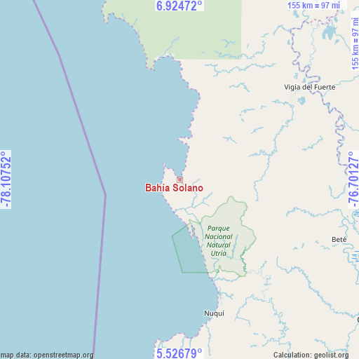
Bahía Solano GPS coordinates[2]
6° 13' 34.392" North, 77° 24' 15.804" West
| Map corner | latitude | longitude |
|---|---|---|
| Upper-left | 6.92472°, | -78.10752° |
| Center: | 6.22622°, | -77.40439° |
| Lower-right: | 5.52679°, | -76.70127° |
| Map W x H: | 155.4×155.4 km | = 96.6×96.6mi |
| max Lat: | 13.38166° ⇑36.6% North |
| Bahía Solano: | 6.22622° |
| min Lat: | ⇓63.4% South -4.21528° |
| min Long | Bahía Solano | max Long |
| -81.70636° | -77.40439° | -67.06996° |
| W 4.4%⇐ | ⇒95.6% E |
Elevation
Elevation of Bahía Solano is 6 m = 20 ft, and this is 1143.3 m = 3751 ft below average elevation for this country.
| Max E: |
3342 m = 10965 ft | 98.5% |
| Avg. | 1149.3 m = 3771 ft | |
| Bahía Solano | 6 m = 20 ft | |
Min E: |
1 m = 3 ft | 1.5% |
See also: Colombia elevation on elevation.city.
Geographical zone
Bahía Solano is located in North Torrid zone (between Equator and Tropic of Cancer). Distance of Equator is 692.3 km =430.2 mi to South.| Distance of | km | miles | from Bahía Solano |
|---|---|---|---|
| North Pole | 9314.8 | 5787.9 | to North |
| Arctic Circle | 6708.9 | 4168.7 | to North |
| Tropic Cancer | 1913.6 | 1189.1 | to North |
| Equator | 692.3 | 430.2 | to South |


Nearby cities:
15 places around Bahía Solano: (largest is in red/bold)
• Bellavista
68.2 km =42.4 mi,  57°
57°
• Beté
73.6 km =45.7 mi,  110°
110°
• Curbaradó
114.1 km =70.9 mi,  24°
24°
• El Cantón de San Pablo
123.6 km =76.8 mi,  142°
142°
• Juradó
105.3 km =65.4 mi,  337°
337°
• Lloró
124.6 km =77.4 mi,  130°
130°
• Managrú
124.1 km =77.1 mi, 142°
• Murindó
105.8 km =65.7 mi,  37°
37°
• Nuquí
59 km =36.7 mi,  165°
165°
• Paimadó
110.5 km =68.7 mi, 138°
• Pie de Pató
92.2 km =57.3 mi,  148°
148°
• Puerto Meluk
123.1 km =76.5 mi,  155°
155°
• Quibdó
101.7 km =63.2 mi, 125°
• Vigía del Fuerte
69.2 km =43 mi,  54°
54°
• Yuto
114.9 km =71.4 mi, 132°
Sources, notices
• [Note1] Compared only with cities in Colombia existing in our database
• [Src1] Map data: © OpenStreetMap contributors (CC-BY-SA)
• [Src2] Other city data from geonames.org with taken over terms of usage.
• [Src3] Geographical zone / Annual Mean Temperature by Robert A. Rohde @ Wikipedia
