Machetá geodata
Machetá (Cundinamarca) is a seat of a second-order administrative division; located in Colombia in America/Bogota (GMT-5) time zone. With population of 1,742 people, there are 828 cities with bigger population in this country. Compared to other cities in Colombia, 59.9% of cities are located further ↑North; 73.4% of cities are located further ←West and 81.5% of cities have lower elevation than Machetá. Note1


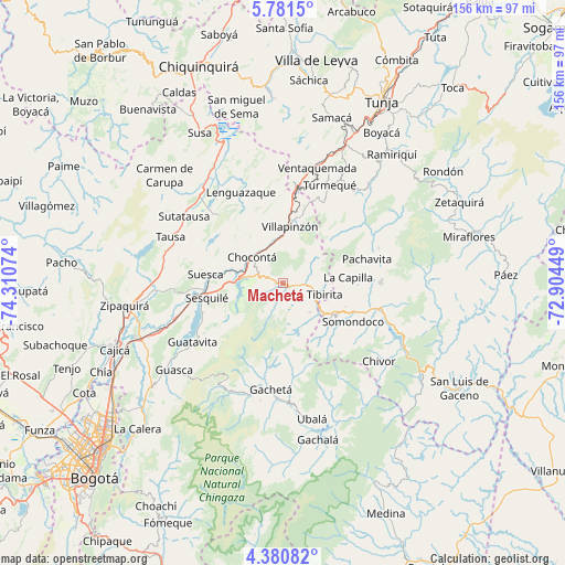
Machetá GPS coordinates[2]
5° 4' 53.544" North, 73° 36' 27.396" West
| Map corner | latitude | longitude |
|---|---|---|
| Upper-left | 5.7815°, | -74.31074° |
| Center: | 5.08154°, | -73.60761° |
| Lower-right: | 4.38082°, | -72.90449° |
| Map W x H: | 155.7×155.7 km | = 96.7×96.7mi |
| max Lat: | 13.38166° ⇑59.9% North |
| Machetá: | 5.08154° |
| min Lat: | ⇓40.1% South -4.21528° |
| min Long | Machetá | max Long |
| -81.70636° | -73.60761° | -67.06996° |
| W 73.4%⇐ | ⇒26.6% E |
Elevation
Elevation of Machetá is 2117 m = 6946 ft, and this is 967.7 m = 3175 ft above average elevation for this country.
| Max E: |
3342 m = 10965 ft | 18.5% |
| Machetá | 2117 m 6946 ft | |
| Avg. | 1149.3 m = 3771 ft | |
Min E: |
1 m = 3 ft | 81.5% |
See also: Colombia elevation on elevation.city.
Geographical zone
Machetá is located in North Torrid zone (between Equator and Tropic of Cancer). Distance of Equator is 565 km =351.1 mi to South.| Distance of | km | miles | from Machetá |
|---|---|---|---|
| North Pole | 9442 | 5867 | to North |
| Arctic Circle | 6836.2 | 4247.8 | to North |
| Tropic Cancer | 2040.9 | 1268.2 | to North |
| Equator | 565 | 351.1 | to South |


Nearby cities:
15 places around Machetá: (largest is in red/bold)
• Chocontá
11.1 km =6.9 mi,  309°
309°
• Cucunubá
25.6 km =15.9 mi,  316°
316°
• Guateque
17.1 km =10.6 mi,  119°
119°
• Guayatá
18.6 km =11.6 mi,  134°
134°
• La Capilla
18.2 km =11.3 mi,  84°
84°
• Manta
10.9 km =6.8 mi,  137°
137°
• Pachavita
24.2 km =15 mi,  74°
74°
• Sesquilé
21.4 km =13.3 mi,  258°
258°
• Somondoco
22.2 km =13.8 mi, 118°
• Suesca
21.3 km =13.2 mi,  276°
276°
• Sutatenza
18.4 km =11.4 mi,  110°
110°
• Tenza
20.7 km =12.9 mi,  91°
91°
• Tibirita
11.9 km =7.4 mi, 105°
• Villapinzón
15 km =9.3 mi,  5°
5°
• Úmbita
22.7 km =14.1 mi,  47°
47°
Sources, notices
• [Note1] Compared only with cities in Colombia existing in our database
• [Src1] Map data: © OpenStreetMap contributors (CC-BY-SA)
• [Src2] Other city data from geonames.org with taken over terms of usage.
• [Src3] Geographical zone / Annual Mean Temperature by Robert A. Rohde @ Wikipedia
