Suesca geodata
Suesca (Cundinamarca) is a seat of a second-order administrative division; located in Colombia in America/Bogota (GMT-5) time zone. With population of 4,877 people, there are 517 cities with bigger population in this country. Compared to other cities in Colombia, 59.4% of cities are located further ↑North; 69.9% of cities are located further ←West and 92% of cities have lower elevation than Suesca. Note1


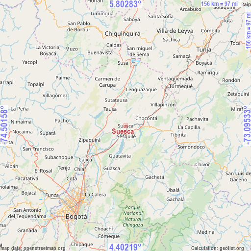
Suesca GPS coordinates[2]
5° 6' 10.404" North, 73° 47' 54.42" West
| Map corner | latitude | longitude |
|---|---|---|
| Upper-left | 5.80283°, | -74.50158° |
| Center: | 5.10289°, | -73.79845° |
| Lower-right: | 4.40219°, | -73.09533° |
| Map W x H: | 155.7×155.7 km | = 96.7×96.7mi |
| max Lat: | 13.38166° ⇑59.4% North |
| Suesca: | 5.10289° |
| min Lat: | ⇓40.6% South -4.21528° |
| min Long | Suesca | max Long |
| -81.70636° | -73.79845° | -67.06996° |
| W 69.9%⇐ | ⇒30.1% E |
Elevation
Elevation of Suesca is 2580 m = 8465 ft, and this is 1430.7 m = 4694 ft above average elevation for this country.
| Max E: |
3342 m = 10965 ft | 8% |
| Suesca | 2580 m 8465 ft | |
| Avg. | 1149.3 m = 3771 ft | |
Min E: |
1 m = 3 ft | 92% |
See also: Colombia elevation on elevation.city.
Geographical zone
Suesca is located in North Torrid zone (between Equator and Tropic of Cancer). Distance of Equator is 567.4 km =352.6 mi to South.| Distance of | km | miles | from Suesca |
|---|---|---|---|
| North Pole | 9439.7 | 5865.6 | to North |
| Arctic Circle | 6833.8 | 4246.3 | to North |
| Tropic Cancer | 2038.5 | 1266.7 | to North |
| Equator | 567.4 | 352.6 | to South |


Nearby cities:
15 places around Suesca: (largest is in red/bold)
• Chocontá
13.3 km =8.3 mi,  69°
69°
• Cogua
20.6 km =12.8 mi,  256°
256°
• Cucunubá
16.7 km =10.4 mi,  12°
12°
• Gachancipá
14.8 km =9.2 mi,  213°
213°
• Guatavita
18.9 km =11.7 mi,  191°
191°
• La Mesa
22.4 km =13.9 mi,  324°
324°
• Lenguazaque
24.7 km =15.3 mi,  22°
22°
• Machetá
21.3 km =13.2 mi,  96°
96°
• Nemocón
9.6 km =6 mi,  245°
245°
• Sesquilé
6.5 km =4 mi,  178°
178°
• Sutatausa
17.2 km =10.7 mi,  339°
339°
• Tausa
14.8 km =9.2 mi, 316°
• Tocancipá
19.9 km =12.4 mi,  219°
219°
• Villa de San Diego de Ubaté
23 km =14.3 mi,  355°
355°
• Zipaquirá
24.6 km =15.3 mi, 248°
Sources, notices
• [Note1] Compared only with cities in Colombia existing in our database
• [Src1] Map data: © OpenStreetMap contributors (CC-BY-SA)
• [Src2] Other city data from geonames.org with taken over terms of usage.
• [Src3] Geographical zone / Annual Mean Temperature by Robert A. Rohde @ Wikipedia
