Manta geodata
Manta (Cundinamarca) is a seat of a second-order administrative division; located in Colombia in America/Bogota (GMT-5) time zone. With population of 1,410 people, there are 882 cities with bigger population in this country. Compared to other cities in Colombia, 62% of cities are located further ↑North; 74.5% of cities are located further ←West and 77.1% of cities have lower elevation than Manta. Note1


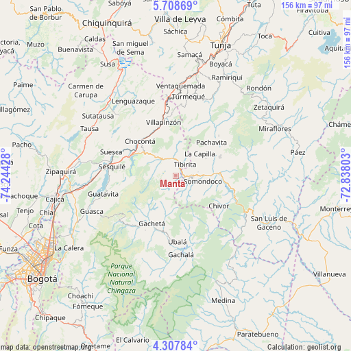
Manta GPS coordinates[2]
5° 0' 31.104" North, 73° 32' 28.14" West
| Map corner | latitude | longitude |
|---|---|---|
| Upper-left | 5.70869°, | -74.24428° |
| Center: | 5.00864°, | -73.54115° |
| Lower-right: | 4.30784°, | -72.83803° |
| Map W x H: | 155.8×155.8 km | = 96.8×96.8mi |
| max Lat: | 13.38166° ⇑62% North |
| Manta: | 5.00864° |
| min Lat: | ⇓38% South -4.21528° |
| min Long | Manta | max Long |
| -81.70636° | -73.54115° | -67.06996° |
| W 74.5%⇐ | ⇒25.5% E |
Elevation
Elevation of Manta is 1920 m = 6299 ft, and this is 770.7 m = 2529 ft above average elevation for this country.
| Max E: |
3342 m = 10965 ft | 22.9% |
| Manta | 1920 m 6299 ft | |
| Avg. | 1149.3 m = 3771 ft | |
Min E: |
1 m = 3 ft | 77.1% |
See also: Colombia elevation on elevation.city.
Geographical zone
Manta is located in North Torrid zone (between Equator and Tropic of Cancer). Distance of Equator is 556.9 km =346 mi to South.| Distance of | km | miles | from Manta |
|---|---|---|---|
| North Pole | 9450.2 | 5872.1 | to North |
| Arctic Circle | 6844.3 | 4252.8 | to North |
| Tropic Cancer | 2049 | 1273.2 | to North |
| Equator | 556.9 | 346 | to South |


Nearby cities:
15 places around Manta: (largest is in red/bold)
• Almeida
18.4 km =11.4 mi,  103°
103°
• Chivor
23.5 km =14.6 mi,  125°
125°
• Chocontá
22 km =13.7 mi,  313°
313°
• Gachetá
23.6 km =14.7 mi,  206°
206°
• Garagoa
21.3 km =13.2 mi,  67°
67°
• Guateque
7.6 km =4.7 mi,  92°
92°
• Guayatá
7.7 km =4.8 mi, 129°
• La Capilla
14.5 km =9 mi,  47°
47°
• Machetá
10.9 km =6.8 mi,  317°
317°
• Pachavita
21.6 km =13.4 mi, 47°
• Somondoco
12.3 km =7.6 mi, 102°
• Sutatenza
10 km =6.2 mi,  80°
80°
• Tenza
15.3 km =9.5 mi,  60°
60°
• Tibirita
6.3 km =3.9 mi,  39°
39°
• Villapinzón
23.8 km =14.8 mi,  345°
345°
Sources, notices
• [Note1] Compared only with cities in Colombia existing in our database
• [Src1] Map data: © OpenStreetMap contributors (CC-BY-SA)
• [Src2] Other city data from geonames.org with taken over terms of usage.
• [Src3] Geographical zone / Annual Mean Temperature by Robert A. Rohde @ Wikipedia
