La Unión geodata
La Unión (Sucre) is a seat of a second-order administrative division; located in Colombia in America/Bogota (GMT-5) time zone. With population of 4,427 people, there are 546 cities with bigger population in this country. Compared to other cities in Colombia, 85.7% of cities are located further ↓South; 61% of cities are located further →East and 86.6% of cities have higher elevation than La Unión. Note1


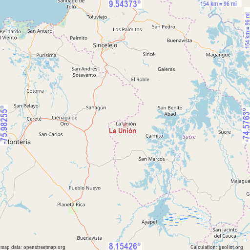
La Unión GPS coordinates[2]
8° 50' 58.74" North, 75° 16' 45.912" West
| Map corner | latitude | longitude |
|---|---|---|
| Upper-left | 9.54373°, | -75.98255° |
| Center: | 8.84965°, | -75.27942° |
| Lower-right: | 8.15426°, | -74.5763° |
| Map W x H: | 154.5×154.5 km | = 96×96mi |
| max Lat: | 13.38166° ⇑14.3% North |
| La Unión: | 8.84965° |
| min Lat: | ⇓85.7% South -4.21528° |
| min Long | La Unión | max Long |
| -81.70636° | -75.27942° | -67.06996° |
| W 39%⇐ | ⇒61% E |
Elevation
Elevation of La Unión is 49 m = 161 ft, and this is 1100.3 m = 3610 ft below average elevation for this country.
| Max E: |
3342 m = 10965 ft | 86.6% |
| Avg. | 1149.3 m = 3771 ft | |
| La Unión | 49 m = 161 ft | |
Min E: |
1 m = 3 ft | 13.4% |
See also: Colombia elevation on elevation.city.
Geographical zone
La Unión is located in North Torrid zone (between Equator and Tropic of Cancer). Distance of Equator is 984 km =611.4 mi to South.| Distance of | km | miles | from La Unión |
|---|---|---|---|
| North Pole | 9023.1 | 5606.7 | to North |
| Arctic Circle | 6417.2 | 3987.5 | to North |
| Tropic Cancer | 1621.9 | 1007.8 | to North |
| Equator | 984 | 611.4 | to South |


Nearby cities:
15 places around La Unión: (largest is in red/bold)
• Caimito
19.1 km =11.9 mi,  110°
110°
• Chinú
31.3 km =19.4 mi,  335°
335°
• Ciénaga de Oro
37.5 km =23.3 mi,  274°
274°
• El Roble
29.5 km =18.3 mi,  18°
18°
• Galeras
42.9 km =26.7 mi,  36°
36°
• Pueblo Nuevo
46.2 km =28.7 mi,  212°
212°
• Sahagún
20.9 km =13 mi,  300°
300°
• Sampués
38.8 km =24.1 mi, 343°
• San Andrés de Sotavento
41.4 km =25.7 mi,  322°
322°
• San Benito Abad
29.1 km =18.1 mi,  72°
72°
• San Carlos
46.5 km =28.9 mi,  262°
262°
• San Juan de Betulia
47.3 km =29.4 mi,  5°
5°
• San Luis de Sincé
46.2 km =28.7 mi, 18°
• San Marcos
26.9 km =16.7 mi,  141°
141°
• Tuchín
48.1 km =29.9 mi, 321°
Sources, notices
• [Note1] Compared only with cities in Colombia existing in our database
• [Src1] Map data: © OpenStreetMap contributors (CC-BY-SA)
• [Src2] Other city data from geonames.org with taken over terms of usage.
• [Src3] Geographical zone / Annual Mean Temperature by Robert A. Rohde @ Wikipedia
