San Marcos geodata
San Marcos (Sucre) is a seat of a second-order administrative division; located in Colombia in America/Bogota (GMT-5) time zone. With population of 36,549 people, there are 105 cities with bigger population in this country. Compared to other cities in Colombia, 84.7% of cities are located further ↓South; 57.2% of cities are located further →East and 91.2% of cities have higher elevation than San Marcos. Note1


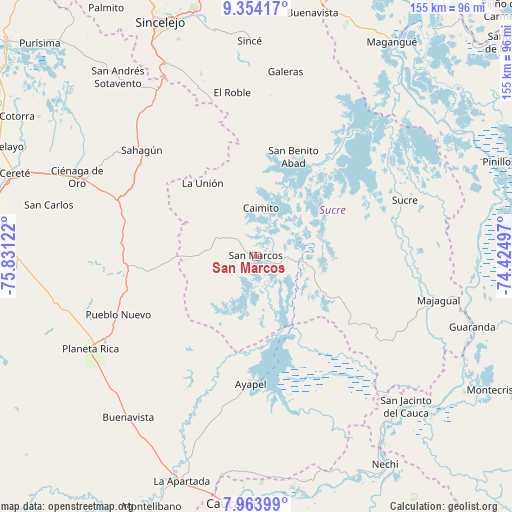
San Marcos GPS coordinates[2]
8° 39' 34.992" North, 75° 7' 41.124" West
| Map corner | latitude | longitude |
|---|---|---|
| Upper-left | 9.35417°, | -75.83122° |
| Center: | 8.65972°, | -75.12809° |
| Lower-right: | 7.96399°, | -74.42497° |
| Map W x H: | 154.6×154.6 km | = 96.1×96.1mi |
| max Lat: | 13.38166° ⇑15.3% North |
| San Marcos: | 8.65972° |
| min Lat: | ⇓84.7% South -4.21528° |
| min Long | San Marcos | max Long |
| -81.70636° | -75.12809° | -67.06996° |
| W 42.8%⇐ | ⇒57.2% E |
Elevation
Elevation of San Marcos is 25 m = 82 ft, and this is 1124.3 m = 3689 ft below average elevation for this country.
| Max E: |
3342 m = 10965 ft | 91.2% |
| Avg. | 1149.3 m = 3771 ft | |
| San Marcos | 25 m = 82 ft | |
Min E: |
1 m = 3 ft | 8.8% |
See also: Colombia elevation on elevation.city.
Geographical zone
San Marcos is located in North Torrid zone (between Equator and Tropic of Cancer). Distance of Equator is 962.9 km =598.3 mi to South.| Distance of | km | miles | from San Marcos |
|---|---|---|---|
| North Pole | 9044.2 | 5619.8 | to North |
| Arctic Circle | 6438.3 | 4000.6 | to North |
| Tropic Cancer | 1643 | 1020.9 | to North |
| Equator | 962.9 | 598.3 | to South |


Nearby cities:
15 places around San Marcos: (largest is in red/bold)
• Ayapel
38.5 km =23.9 mi,  181°
181°
• Buenavista
62.3 km =38.7 mi,  218°
218°
• Caimito
14.5 km =9 mi,  4°
4°
• Chinú
57.8 km =35.9 mi,  329°
329°
• Ciénaga de Oro
59.1 km =36.7 mi,  293°
293°
• El Roble
49.7 km =30.9 mi,  351°
351°
• Galeras
56.4 km =35 mi,  8°
8°
• La Unión
26.9 km =16.7 mi,  321°
321°
• Majagual
56.4 km =35 mi,  103°
103°
• Planeta Rica
57.3 km =35.6 mi,  241°
241°
• Pueblo Nuevo
45.3 km =28.1 mi,  247°
247°
• Pueblo Nuevo
50.2 km =31.2 mi,  158°
158°
• Sahagún
47 km =29.2 mi,  312°
312°
• San Benito Abad
31.9 km =19.8 mi,  20°
20°
• Sucre
47.8 km =29.7 mi,  69°
69°
Sources, notices
• [Note1] Compared only with cities in Colombia existing in our database
• [Src1] Map data: © OpenStreetMap contributors (CC-BY-SA)
• [Src2] Other city data from geonames.org with taken over terms of usage.
• [Src3] Geographical zone / Annual Mean Temperature by Robert A. Rohde @ Wikipedia
