Guayabal de Síquima geodata
Guayabal de Síquima (Cundinamarca) is a seat of a second-order administrative division; located in Colombia in America/Bogota (GMT-5) time zone. With population of 1,051 people, there are 940 cities with bigger population in this country. Compared to other cities in Colombia, 64.7% of cities are located further ↑North; 57.5% of cities are located further ←West and 65.4% of cities have lower elevation than Guayabal de Síquima. Note1


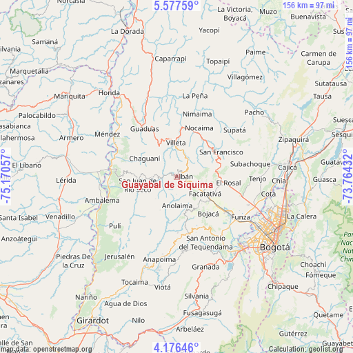
Guayabal de Síquima GPS coordinates[2]
4° 52' 38.604" North, 74° 28' 2.784" West
| Map corner | latitude | longitude |
|---|---|---|
| Upper-left | 5.57759°, | -75.17057° |
| Center: | 4.87739°, | -74.46744° |
| Lower-right: | 4.17646°, | -73.76432° |
| Map W x H: | 155.8×155.8 km | = 96.8×96.8mi |
| max Lat: | 13.38166° ⇑64.7% North |
| Guayabal de Síquima: | 4.87739° |
| min Lat: | ⇓35.3% South -4.21528° |
| min Long | Guayabal de Sí | max Long |
| -81.70636° | -74.46744° | -67.06996° |
| W 57.5%⇐ | ⇒42.5% E |
Elevation
Elevation of Guayabal de Síquima is 1604 m = 5262 ft, and this is 454.7 m = 1492 ft above average elevation for this country.
| Max E: |
3342 m = 10965 ft | 34.6% |
| Guayabal de Síquima | 1604 m 5262 ft | |
| Avg. | 1149.3 m = 3771 ft | |
Min E: |
1 m = 3 ft | 65.4% |
See also: Colombia elevation on elevation.city.
Geographical zone
Guayabal de Síquima is located in North Torrid zone (between Equator and Tropic of Cancer). Distance of Equator is 542.3 km =337 mi to South.| Distance of | km | miles | from Guayabal de Síquima |
|---|---|---|---|
| North Pole | 9464.7 | 5881.1 | to North |
| Arctic Circle | 6858.9 | 4261.9 | to North |
| Tropic Cancer | 2063.6 | 1282.3 | to North |
| Equator | 542.3 | 337 | to South |


Nearby cities:
15 places around Guayabal de Síquima: (largest is in red/bold)
• Albán
3.3 km =2.1 mi,  91°
91°
• Anolaima
6 km =3.7 mi,  216°
216°
• Bituima
8 km =5 mi,  266°
266°
• Bojacá
21.4 km =13.3 mi,  139°
139°
• Cachipay
16.7 km =10.4 mi,  168°
168°
• Chaguaní
16.1 km =10 mi,  299°
299°
• Facatativá
14.4 km =8.9 mi,  119°
119°
• La Vega
19.6 km =12.2 mi,  45°
45°
• Quipile
16.4 km =10.2 mi,  206°
206°
• San Francisco
22.4 km =13.9 mi,  59°
59°
• San Juan de Rioseco
17.4 km =10.8 mi,  259°
259°
• Sasaima
10.6 km =6.6 mi,  19°
19°
• Vianí
10.5 km =6.5 mi, 267°
• Villeta
14.6 km =9.1 mi,  357°
357°
• Zipacón
16.4 km =10.2 mi, 143°
Sources, notices
• [Note1] Compared only with cities in Colombia existing in our database
• [Src1] Map data: © OpenStreetMap contributors (CC-BY-SA)
• [Src2] Other city data from geonames.org with taken over terms of usage.
• [Src3] Geographical zone / Annual Mean Temperature by Robert A. Rohde @ Wikipedia
