Chaguaní geodata
Chaguaní (Cundinamarca) is a seat of a second-order administrative division; located in Colombia in America/Bogota (GMT-5) time zone. With population of 1,108 people, there are 932 cities with bigger population in this country. Compared to other cities in Colombia, 63.6% of cities are located further ↑North; 55% of cities are located further ←West and 52.8% of cities have higher elevation than Chaguaní. Note1


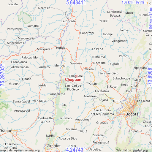
Chaguaní GPS coordinates[2]
4° 56' 53.844" North, 74° 35' 38.112" West
| Map corner | latitude | longitude |
|---|---|---|
| Upper-left | 5.64841°, | -75.29705° |
| Center: | 4.94829°, | -74.59392° |
| Lower-right: | 4.24743°, | -73.8908° |
| Map W x H: | 155.8×155.8 km | = 96.8×96.8mi |
| max Lat: | 13.38166° ⇑63.6% North |
| Chaguaní: | 4.94829° |
| min Lat: | ⇓36.4% South -4.21528° |
| min Long | Chaguaní | max Long |
| -81.70636° | -74.59392° | -67.06996° |
| W 55%⇐ | ⇒45% E |
Elevation
Elevation of Chaguaní is 1030 m = 3379 ft, and this is 119.3 m = 391 ft below average elevation for this country.
| Max E: |
3342 m = 10965 ft | 52.8% |
| Avg. | 1149.3 m = 3771 ft | |
| Chaguaní | 1030 m = 3379 ft | |
Min E: |
1 m = 3 ft | 47.2% |
See also: Colombia elevation on elevation.city.
Geographical zone
Chaguaní is located in North Torrid zone (between Equator and Tropic of Cancer). Distance of Equator is 550.2 km =341.9 mi to South.| Distance of | km | miles | from Chaguaní |
|---|---|---|---|
| North Pole | 9456.9 | 5876.2 | to North |
| Arctic Circle | 6851 | 4257 | to North |
| Tropic Cancer | 2055.7 | 1277.4 | to North |
| Equator | 550.2 | 341.9 | to South |


Nearby cities:
15 places around Chaguaní: (largest is in red/bold)
• Albán
19.1 km =11.9 mi,  114°
114°
• Ambalema
26.1 km =16.2 mi,  225°
225°
• Anolaima
16.5 km =10.3 mi,  140°
140°
• Beltrán
23.1 km =14.4 mi, 225°
• Bituima
10.4 km =6.5 mi, 144°
• Granada
13.5 km =8.4 mi,  12°
12°
• Guaduas
13.2 km =8.2 mi,  359°
359°
• Guayabal de Síquima
16.1 km =10 mi,  119°
119°
• Nocaima
26.7 km =16.6 mi,  60°
60°
• Quebradanegra
22.7 km =14.1 mi,  33°
33°
• Quipile
23.5 km =14.6 mi,  163°
163°
• San Juan de Rioseco
11.6 km =7.2 mi,  195°
195°
• Sasaima
17.7 km =11 mi,  83°
83°
• Vianí
9 km =5.6 mi, 157°
• Villeta
15.1 km =9.4 mi, 63°
Sources, notices
• [Note1] Compared only with cities in Colombia existing in our database
• [Src1] Map data: © OpenStreetMap contributors (CC-BY-SA)
• [Src2] Other city data from geonames.org with taken over terms of usage.
• [Src3] Geographical zone / Annual Mean Temperature by Robert A. Rohde @ Wikipedia
