Bojacá geodata
Bojacá (Cundinamarca) is a seat of a second-order administrative division; located in Colombia in America/Bogota (GMT-5) time zone. With population of 4,399 people, there are 549 cities with bigger population in this country. Compared to other cities in Colombia, 67.8% of cities are located further ↑North; 59.9% of cities are located further ←West and 92.3% of cities have lower elevation than Bojacá. Note1


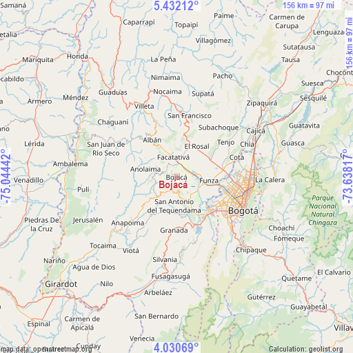
Bojacá GPS coordinates[2]
4° 43' 54.336" North, 74° 20' 28.644" West
| Map corner | latitude | longitude |
|---|---|---|
| Upper-left | 5.43212°, | -75.04442° |
| Center: | 4.73176°, | -74.34129° |
| Lower-right: | 4.03069°, | -73.63817° |
| Map W x H: | 155.8×155.8 km | = 96.8×96.8mi |
| max Lat: | 13.38166° ⇑67.8% North |
| Bojacá: | 4.73176° |
| min Lat: | ⇓32.2% South -4.21528° |
| min Long | Bojacá | max Long |
| -81.70636° | -74.34129° | -67.06996° |
| W 59.9%⇐ | ⇒40.1% E |
Elevation
Elevation of Bojacá is 2583 m = 8474 ft, and this is 1433.7 m = 4704 ft above average elevation for this country.
| Max E: |
3342 m = 10965 ft | 7.7% |
| Bojacá | 2583 m 8474 ft | |
| Avg. | 1149.3 m = 3771 ft | |
Min E: |
1 m = 3 ft | 92.3% |
See also: Colombia elevation on elevation.city.
Geographical zone
Bojacá is located in North Torrid zone (between Equator and Tropic of Cancer). Distance of Equator is 526.1 km =326.9 mi to South.| Distance of | km | miles | from Bojacá |
|---|---|---|---|
| North Pole | 9480.9 | 5891.2 | to North |
| Arctic Circle | 6875.1 | 4272 | to North |
| Tropic Cancer | 2079.8 | 1292.3 | to North |
| Equator | 526.1 | 326.9 | to South |


Nearby cities:
15 places around Bojacá: (largest is in red/bold)
• Albán
19.3 km =12 mi,  326°
326°
• Anolaima
20.9 km =13 mi,  302°
302°
• Cachipay
10.6 km =6.6 mi,  269°
269°
• El Colegio
20.2 km =12.6 mi,  213°
213°
• El Rosal
16.2 km =10.1 mi,  33°
33°
• Facatativá
9.2 km =5.7 mi,  350°
350°
• Funza
14.4 km =8.9 mi,  96°
96°
• Guayabal de Síquima
21.4 km =13.3 mi,  319°
319°
• Madrid
8.5 km =5.3 mi,  89°
89°
• Mosquera
12.6 km =7.8 mi, 103°
• Quipile
21.4 km =13.3 mi, 273°
• San Antonio del Tequendama
12.9 km =8 mi,  185°
185°
• Soacha
21.8 km =13.5 mi,  140°
140°
• Tena
9.8 km =6.1 mi,  215°
215°
• Zipacón
5.3 km =3.3 mi, 304°
Sources, notices
• [Note1] Compared only with cities in Colombia existing in our database
• [Src1] Map data: © OpenStreetMap contributors (CC-BY-SA)
• [Src2] Other city data from geonames.org with taken over terms of usage.
• [Src3] Geographical zone / Annual Mean Temperature by Robert A. Rohde @ Wikipedia
