Sasaima geodata
Sasaima (Cundinamarca) is a populated place; located in Colombia in America/Bogota (GMT-5) time zone. With population of 2,948 people, there are 685 cities with bigger population in this country. Compared to other cities in Colombia, 63% of cities are located further ↑North; 58.1% of cities are located further ←West and 50.6% of cities have lower elevation than Sasaima. Note1


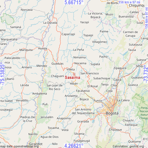
Sasaima GPS coordinates[2]
4° 58' 1.38" North, 74° 26' 6.432" West
| Map corner | latitude | longitude |
|---|---|---|
| Upper-left | 5.66715°, | -75.13825° |
| Center: | 4.96705°, | -74.43512° |
| Lower-right: | 4.26621°, | -73.732° |
| Map W x H: | 155.8×155.8 km | = 96.8×96.8mi |
| max Lat: | 13.38166° ⇑63% North |
| Sasaima: | 4.96705° |
| min Lat: | ⇓37% South -4.21528° |
| min Long | Sasaima | max Long |
| -81.70636° | -74.43512° | -67.06996° |
| W 58.1%⇐ | ⇒41.9% E |
Elevation
Elevation of Sasaima is 1141 m = 3743 ft, and this is 8.3 m = 27 ft below average elevation for this country.
| Max E: |
3342 m = 10965 ft | 49.4% |
| Avg. | 1149.3 m = 3771 ft | |
| Sasaima | 1141 m = 3743 ft | |
Min E: |
1 m = 3 ft | 50.6% |
See also: Colombia elevation on elevation.city.
Geographical zone
Sasaima is located in North Torrid zone (between Equator and Tropic of Cancer). Distance of Equator is 552.3 km =343.2 mi to South.| Distance of | km | miles | from Sasaima |
|---|---|---|---|
| North Pole | 9454.8 | 5874.9 | to North |
| Arctic Circle | 6848.9 | 4255.7 | to North |
| Tropic Cancer | 2053.6 | 1276 | to North |
| Equator | 552.3 | 343.2 | to South |


Nearby cities:
15 places around Sasaima: (largest is in red/bold)
• Albán
10.1 km =6.3 mi,  181°
181°
• Anolaima
16.5 km =10.3 mi,  205°
205°
• Bituima
15.6 km =9.7 mi,  227°
227°
• Chaguaní
17.7 km =11 mi,  263°
263°
• Facatativá
19.2 km =11.9 mi,  152°
152°
• Granada
18.3 km =11.4 mi,  307°
307°
• Guayabal de Síquima
10.6 km =6.6 mi,  199°
199°
• La Vega
11 km =6.8 mi,  69°
69°
• Nimaima
18.5 km =11.5 mi,  17°
17°
• Nocaima
12.4 km =7.7 mi,  26°
26°
• Quebradanegra
17.4 km =10.8 mi,  343°
343°
• San Francisco
15.8 km =9.8 mi,  85°
85°
• Vergara
19.5 km =12.1 mi, 30°
• Vianí
17.5 km =10.9 mi, 233°
• Villeta
6.2 km =3.9 mi,  318°
318°
Sources, notices
• [Note1] Compared only with cities in Colombia existing in our database
• [Src1] Map data: © OpenStreetMap contributors (CC-BY-SA)
• [Src2] Other city data from geonames.org with taken over terms of usage.
• [Src3] Geographical zone / Annual Mean Temperature by Robert A. Rohde @ Wikipedia
