Gaitania geodata
Gaitania (Tolima) is a populated place; located in Colombia in America/Bogota (GMT-5) time zone. With population of 11,000 people, there are 280 cities with bigger population in this country. Compared to other cities in Colombia, 83.7% of cities are located further ↑North; 76.3% of cities are located further →East and 93.8% of cities have lower elevation than Gaitania. Note1


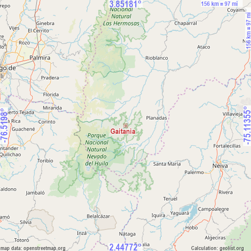
Gaitania GPS coordinates[2]
3° 9' 0" North, 75° 49' 0.012" West
| Map corner | latitude | longitude |
|---|---|---|
| Upper-left | 3.85181°, | -76.5198° |
| Center: | 3.15°, | -75.81667° |
| Lower-right: | 2.44772°, | -75.11355° |
| Map W x H: | 156.1×156.1 km | = 97×97mi |
| max Lat: | 13.38166° ⇑83.7% North |
| Gaitania: | 3.15° |
| min Lat: | ⇓16.3% South -4.21528° |
| min Long | Gaitania | max Long |
| -81.70636° | -75.81667° | -67.06996° |
| W 23.7%⇐ | ⇒76.3% E |
Elevation
Elevation of Gaitania is 2618 m = 8589 ft, and this is 1468.7 m = 4819 ft above average elevation for this country.
| Max E: |
3342 m = 10965 ft | 6.2% |
| Gaitania | 2618 m 8589 ft | |
| Avg. | 1149.3 m = 3771 ft | |
Min E: |
1 m = 3 ft | 93.8% |
See also: Colombia elevation on elevation.city.
Geographical zone
Gaitania is located in North Torrid zone (between Equator and Tropic of Cancer). Distance of Equator is 350.2 km =217.6 mi to South.| Distance of | km | miles | from Gaitania |
|---|---|---|---|
| North Pole | 9656.8 | 6000.5 | to North |
| Arctic Circle | 7050.9 | 4381.2 | to North |
| Tropic Cancer | 2255.7 | 1401.6 | to North |
| Equator | 350.2 | 217.6 | to South |


Nearby cities:
15 places around Gaitania: (largest is in red/bold)
• Belalcázar
58.6 km =36.4 mi,  197°
197°
• Campo Alegre
13.3 km =8.3 mi,  70°
70°
• Corinto
49.6 km =30.8 mi,  272°
272°
• Florida
50.2 km =31.2 mi,  292°
292°
• Miranda
47.2 km =29.3 mi,  284°
284°
• Padilla
55.7 km =34.6 mi, 278°
• Palermo
51 km =31.7 mi,  124°
124°
• Planadas
19.8 km =12.3 mi, 74°
• Pradera
56.3 km =35 mi,  302°
302°
• Rioblanco
46.3 km =28.8 mi,  24°
24°
• Santa María
28.9 km =18 mi,  140°
140°
• Santa María
34.8 km =21.6 mi,  132°
132°
• Santiago Pérez
36.2 km =22.5 mi,  40°
40°
• Teruel
53.2 km =33.1 mi,  148°
148°
• Toribío
54.6 km =33.9 mi,  246°
246°
Sources, notices
• [Note1] Compared only with cities in Colombia existing in our database
• [Src1] Map data: © OpenStreetMap contributors (CC-BY-SA)
• [Src2] Other city data from geonames.org with taken over terms of usage.
• [Src3] Geographical zone / Annual Mean Temperature by Robert A. Rohde @ Wikipedia
