Belalcázar geodata
Belalcázar (Cauca) is a seat of a second-order administrative division; located in Colombia in America/Bogota (GMT-5) time zone. With population of 31,800 people, there are 116 cities with bigger population in this country. Compared to other cities in Colombia, 86% of cities are located further ↑North; 79.4% of cities are located further →East and 77.5% of cities have lower elevation than Belalcázar. Note1


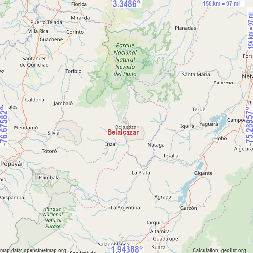
Belalcázar GPS coordinates[2]
2° 38' 47.184" North, 75° 58' 21.684" West
| Map corner | latitude | longitude |
|---|---|---|
| Upper-left | 3.3486°, | -76.67582° |
| Center: | 2.64644°, | -75.97269° |
| Lower-right: | 1.94388°, | -75.26957° |
| Map W x H: | 156.2×156.2 km | = 97.1×97.1mi |
| max Lat: | 13.38166° ⇑86% North |
| Belalcázar: | 2.64644° |
| min Lat: | ⇓14% South -4.21528° |
| min Long | Belalcázar | max Long |
| -81.70636° | -75.97269° | -67.06996° |
| W 20.6%⇐ | ⇒79.4% E |
Elevation
Elevation of Belalcázar is 1943 m = 6375 ft, and this is 793.7 m = 2604 ft above average elevation for this country.
| Max E: |
3342 m = 10965 ft | 22.5% |
| Belalcázar | 1943 m 6375 ft | |
| Avg. | 1149.3 m = 3771 ft | |
Min E: |
1 m = 3 ft | 77.5% |
See also: Colombia elevation on elevation.city.
Geographical zone
Belalcázar is located in North Torrid zone (between Equator and Tropic of Cancer). Distance of Equator is 294.3 km =182.9 mi to South.| Distance of | km | miles | from Belalcázar |
|---|---|---|---|
| North Pole | 9712.8 | 6035.3 | to North |
| Arctic Circle | 7106.9 | 4416 | to North |
| Tropic Cancer | 2311.7 | 1436.4 | to North |
| Equator | 294.3 | 182.9 | to South |


Nearby cities:
15 places around Belalcázar: (largest is in red/bold)
• Agrado
48.7 km =30.3 mi,  152°
152°
• Inzá
14.7 km =9.1 mi,  225°
225°
• Jambaló
41.7 km =25.9 mi,  290°
290°
• La Argentina
49.9 km =31 mi,  180°
180°
• La Plata
29.5 km =18.3 mi,  162°
162°
• Nátaga
21.5 km =13.4 mi,  122°
122°
• Paicol
31 km =19.3 mi,  134°
134°
• Pital
46.2 km =28.7 mi, 156°
• Santa María
49.2 km =30.6 mi,  46°
46°
• Silvia
45.7 km =28.4 mi,  265°
265°
• Teruel
46.3 km =28.8 mi,  76°
76°
• Tesalia
32.4 km =20.1 mi, 123°
• Toribío
47.5 km =29.5 mi,  316°
316°
• Totoró
50 km =31.1 mi,  252°
252°
• Íquira
37.6 km =23.4 mi,  89°
89°
Sources, notices
• [Note1] Compared only with cities in Colombia existing in our database
• [Src1] Map data: © OpenStreetMap contributors (CC-BY-SA)
• [Src2] Other city data from geonames.org with taken over terms of usage.
• [Src3] Geographical zone / Annual Mean Temperature by Robert A. Rohde @ Wikipedia
