Santa María geodata
Santa María (Huila) is a populated place; located in Colombia in America/Bogota (GMT-5) time zone. With population of 2,761 people, there are 705 cities with bigger population in this country. Compared to other cities in Colombia, 84.5% of cities are located further ↑North; 70.7% of cities are located further →East and 70.5% of cities have lower elevation than Santa María. Note1


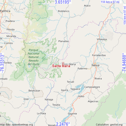
Santa María GPS coordinates[2]
2° 57' 0" North, 75° 39' 0" West
| Map corner | latitude | longitude |
|---|---|---|
| Upper-left | 3.65195°, | -76.35313° |
| Center: | 2.95°, | -75.65° |
| Lower-right: | 2.2476°, | -74.94688° |
| Map W x H: | 156.1×156.2 km | = 97×97.1mi |
| max Lat: | 13.38166° ⇑84.5% North |
| Santa María: | 2.95° |
| min Lat: | ⇓15.5% South -4.21528° |
| min Long | Santa María | max Long |
| -81.70636° | -75.65° | -67.06996° |
| W 29.3%⇐ | ⇒70.7% E |
Elevation
Elevation of Santa María is 1745 m = 5725 ft, and this is 595.7 m = 1954 ft above average elevation for this country.
| Max E: |
3342 m = 10965 ft | 29.5% |
| Santa María | 1745 m 5725 ft | |
| Avg. | 1149.3 m = 3771 ft | |
Min E: |
1 m = 3 ft | 70.5% |
See also: Colombia elevation on elevation.city.
Geographical zone
Santa María is located in North Torrid zone (between Equator and Tropic of Cancer). Distance of Equator is 328 km =203.8 mi to South.| Distance of | km | miles | from Santa María |
|---|---|---|---|
| North Pole | 9679.1 | 6014.3 | to North |
| Arctic Circle | 7073.2 | 4395.1 | to North |
| Tropic Cancer | 2277.9 | 1415.4 | to North |
| Equator | 328 | 203.8 | to South |


Nearby cities:
15 places around Santa María: (largest is in red/bold)
• Belalcázar
49.2 km =30.6 mi,  226°
226°
• Campo Alegre
27.3 km =17 mi,  347°
347°
• Campoalegre
46.8 km =29.1 mi,  129°
129°
• Gaitania
28.9 km =18 mi,  320°
320°
• Hobo
46.4 km =28.8 mi,  151°
151°
• Neiva
41 km =25.5 mi,  93°
93°
• Nátaga
48.5 km =30.1 mi,  201°
201°
• Palermo
24.5 km =15.2 mi,  105°
105°
• Planadas
27.5 km =17.1 mi,  1°
1°
• Rivera
47.7 km =29.6 mi, 113°
• Santa María
7.2 km =4.5 mi,  99°
99°
• Santiago Pérez
50.1 km =31.1 mi,  5°
5°
• Teruel
24.9 km =15.5 mi,  158°
158°
• Yaguará
35.1 km =21.8 mi, 155°
• Íquira
33.5 km =20.8 mi,  177°
177°
Sources, notices
• [Note1] Compared only with cities in Colombia existing in our database
• [Src1] Map data: © OpenStreetMap contributors (CC-BY-SA)
• [Src2] Other city data from geonames.org with taken over terms of usage.
• [Src3] Geographical zone / Annual Mean Temperature by Robert A. Rohde @ Wikipedia
