Santiago Pérez geodata
Santiago Pérez (Tolima) is a populated place; located in Colombia in America/Bogota (GMT-5) time zone. With population of 3,115 people, there are 673 cities with bigger population in this country. Compared to other cities in Colombia, 82% of cities are located further ↑North; 69.1% of cities are located further →East and 60.7% of cities have higher elevation than Santiago Pérez. Note1


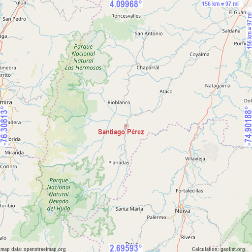
Santiago Pérez GPS coordinates[2]
3° 23' 53.016" North, 75° 36' 18" West
| Map corner | latitude | longitude |
|---|---|---|
| Upper-left | 4.09968°, | -76.30813° |
| Center: | 3.39806°, | -75.605° |
| Lower-right: | 2.69593°, | -74.90188° |
| Map W x H: | 156.1×156.1 km | = 97×97mi |
| max Lat: | 13.38166° ⇑82% North |
| Santiago Pérez: | 3.39806° |
| min Lat: | ⇓18% South -4.21528° |
| min Long | Santiago Pérez | max Long |
| -81.70636° | -75.605° | -67.06996° |
| W 30.9%⇐ | ⇒69.1% E |
Elevation
Elevation of Santiago Pérez is 690 m = 2264 ft, and this is 459.3 m = 1507 ft below average elevation for this country.
| Max E: |
3342 m = 10965 ft | 60.7% |
| Avg. | 1149.3 m = 3771 ft | |
| Santiago Pérez | 690 m = 2264 ft | |
Min E: |
1 m = 3 ft | 39.3% |
See also: Colombia elevation on elevation.city.
Geographical zone
Santiago Pérez is located in North Torrid zone (between Equator and Tropic of Cancer). Distance of Equator is 377.8 km =234.8 mi to South.| Distance of | km | miles | from Santiago Pérez |
|---|---|---|---|
| North Pole | 9629.2 | 5983.3 | to North |
| Arctic Circle | 7023.3 | 4364.1 | to North |
| Tropic Cancer | 2228.1 | 1384.5 | to North |
| Equator | 377.8 | 234.8 | to South |


Nearby cities:
15 places around Santiago Pérez: (largest is in red/bold)
• Aipe
45.3 km =28.1 mi,  115°
115°
• Ataco
32.8 km =20.4 mi,  49°
49°
• Campo Alegre
25.7 km =16 mi,  205°
205°
• Chaparral
38.6 km =24 mi,  20°
20°
• Gaitania
36.2 km =22.5 mi,  220°
220°
• La Cumbre
58.6 km =36.4 mi,  308°
308°
• Natagaima
61.9 km =38.5 mi,  66°
66°
• Neiva
63.5 km =39.5 mi,  145°
145°
• Palermo
59.3 km =36.8 mi,  161°
161°
• Planadas
22.8 km =14.2 mi,  191°
191°
• Rioblanco
15.3 km =9.5 mi,  343°
343°
• San Antonio
59 km =36.7 mi,  13°
13°
• Santa María
50.1 km =31.1 mi, 185°
• Santa María
51.1 km =31.8 mi,  177°
177°
• Villavieja
47.2 km =29.3 mi,  114°
114°
Sources, notices
• [Note1] Compared only with cities in Colombia existing in our database
• [Src1] Map data: © OpenStreetMap contributors (CC-BY-SA)
• [Src2] Other city data from geonames.org with taken over terms of usage.
• [Src3] Geographical zone / Annual Mean Temperature by Robert A. Rohde @ Wikipedia
