Floresta geodata
Floresta (Boyacá) is a seat of a second-order administrative division; located in Colombia in America/Bogota (GMT-5) time zone. With population of 1,127 people, there are 927 cities with bigger population in this country. Compared to other cities in Colombia, 56.6% of cities are located further ↓South; 88.3% of cities are located further ←West and 88.8% of cities have lower elevation than Floresta. Note1


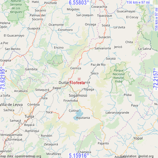
Floresta GPS coordinates[2]
5° 51' 32.508" North, 72° 55' 7.752" West
| Map corner | latitude | longitude |
|---|---|---|
| Upper-left | 6.55803°, | -73.62195° |
| Center: | 5.85903°, | -72.91882° |
| Lower-right: | 5.15916°, | -72.2157° |
| Map W x H: | 155.5×155.5 km | = 96.6×96.6mi |
| max Lat: | 13.38166° ⇑43.4% North |
| Floresta: | 5.85903° |
| min Lat: | ⇓56.6% South -4.21528° |
| min Long | Floresta | max Long |
| -81.70636° | -72.91882° | -67.06996° |
| W 88.3%⇐ | ⇒11.7% E |
Elevation
Elevation of Floresta is 2503 m = 8212 ft, and this is 1353.7 m = 4441 ft above average elevation for this country.
| Max E: |
3342 m = 10965 ft | 11.2% |
| Floresta | 2503 m 8212 ft | |
| Avg. | 1149.3 m = 3771 ft | |
Min E: |
1 m = 3 ft | 88.8% |
See also: Colombia elevation on elevation.city.
Geographical zone
Floresta is located in North Torrid zone (between Equator and Tropic of Cancer). Distance of Equator is 651.5 km =404.8 mi to South.| Distance of | km | miles | from Floresta |
|---|---|---|---|
| North Pole | 9355.6 | 5813.3 | to North |
| Arctic Circle | 6749.7 | 4194.1 | to North |
| Tropic Cancer | 1954.5 | 1214.5 | to North |
| Equator | 651.5 | 404.8 | to South |


Nearby cities:
15 places around Floresta: (largest is in red/bold)
• Belén
14.5 km =9 mi,  2°
2°
• Betéitiva
13.4 km =8.3 mi,  64°
64°
• Busbanzá
5 km =3.1 mi,  129°
129°
• Cerinza
11.2 km =7 mi,  343°
343°
• Corrales
9 km =5.6 mi,  111°
111°
• Duitama
13.3 km =8.3 mi,  253°
253°
• Gámeza
14 km =8.7 mi,  116°
116°
• Mongua
17.5 km =10.9 mi, 133°
• Monguí
17.1 km =10.6 mi,  153°
153°
• Nobsa
10.2 km =6.3 mi,  193°
193°
• Santa Rosa de Viterbo
7.2 km =4.5 mi,  283°
283°
• Sogamoso
16.2 km =10.1 mi, 185°
• Tasco
16.4 km =10.2 mi,  69°
69°
• Tibasosa
15.1 km =9.4 mi,  216°
216°
• Tópaga
15.1 km =9.4 mi,  137°
137°
Sources, notices
• [Note1] Compared only with cities in Colombia existing in our database
• [Src1] Map data: © OpenStreetMap contributors (CC-BY-SA)
• [Src2] Other city data from geonames.org with taken over terms of usage.
• [Src3] Geographical zone / Annual Mean Temperature by Robert A. Rohde @ Wikipedia
