Santa Rosa de Viterbo geodata
Santa Rosa de Viterbo (Boyacá) is a seat of a second-order administrative division; located in Colombia in America/Bogota (GMT-5) time zone. With population of 6,923 people, there are 412 cities with bigger population in this country. Compared to other cities in Colombia, 57% of cities are located further ↓South; 86.8% of cities are located further ←West and 96.7% of cities have lower elevation than Santa Rosa de Viterbo. Note1
Current local time in Santa Rosa de Viterbo:
08:08 AM, WednesdayDifference from your time zone: hours


Santa Rosa de Viterbo GPS coordinates[2]
5° 52' 26.436" North, 72° 58' 55.812" West
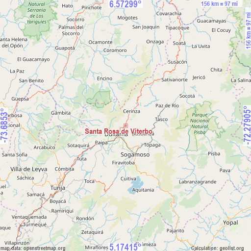
| Map corner | latitude | longitude |
|---|---|---|
| Upper-left | 6.57299°, | -73.6853° |
| Center: | 5.87401°, | -72.98217° |
| Lower-right: | 5.17415°, | -72.27905° |
| Map W x H: | 155.5×155.5 km | = 96.6×96.6mi |
| max Lat: | 13.38166° ⇑43% North |
| Santa Rosa de Viterbo: | 5.87401° |
| min Lat: | ⇓57% South -4.21528° |
| min Long | Santa Rosa de V | max Long |
| -81.70636° | -72.98217° | -67.06996° |
| W 86.8%⇐ | ⇒13.2% E |
Elevation
Elevation of Santa Rosa de Viterbo is 2752 m = 9029 ft, and this is 1602.7 m = 5258 ft above average elevation for this country.
| Max E: |
3342 m = 10965 ft | 3.3% |
| Santa Rosa de Viterbo | 2752 m 9029 ft | |
| Avg. | 1149.3 m = 3771 ft | |
Min E: |
1 m = 3 ft | 96.7% |
See also: Colombia elevation on elevation.city.
Geographical zone
Santa Rosa de Viterbo is located in North Torrid zone (between Equator and Tropic of Cancer). Distance of Equator is 653.1 km =405.8 mi to South.| Distance of | km | miles | from Santa Rosa de Viterbo |
|---|---|---|---|
| North Pole | 9353.9 | 5812.2 | to North |
| Arctic Circle | 6748 | 4193 | to North |
| Tropic Cancer | 1952.8 | 1213.4 | to North |
| Equator | 653.1 | 405.8 | to South |


Nearby cities:
15 places around Santa Rosa de Viterbo: (largest is in red/bold)
• Belén
14.9 km =9.3 mi,  31°
31°
• Betéitiva
19.6 km =12.2 mi,  77°
77°
• Busbanzá
11.9 km =7.4 mi,  114°
114°
• Cerinza
9.8 km =6.1 mi,  22°
22°
• Corrales
16.1 km =10 mi, 107°
• Duitama
8 km =5 mi,  226°
226°
• Floresta
7.2 km =4.5 mi,  103°
103°
• Gámeza
21.1 km =13.1 mi, 112°
• Monguí
22.5 km =14 mi,  139°
139°
• Nobsa
12.5 km =7.8 mi,  158°
158°
• Paipa
18.2 km =11.3 mi,  235°
235°
• Sogamoso
18.5 km =11.5 mi, 163°
• Tibasosa
13.9 km =8.6 mi,  188°
188°
• Tutazá
22.4 km =13.9 mi,  38°
38°
• Tópaga
21.5 km =13.4 mi,  126°
126°
Sources, notices
• [Note1] Compared only with cities in Colombia existing in our database
• [Src1] Map data: © OpenStreetMap contributors (CC-BY-SA)
• [Src2] Other city data from geonames.org with taken over terms of usage.
• [Src3] Geographical zone / Annual Mean Temperature by Robert A. Rohde @ Wikipedia
