Belén geodata
Belén (Boyacá) is a seat of a second-order administrative division; located in Colombia in America/Bogota (GMT-5) time zone. With population of 5,411 people, there are 478 cities with bigger population in this country. Compared to other cities in Colombia, 59.1% of cities are located further ↓South; 88.4% of cities are located further ←West and 94.4% of cities have lower elevation than Belén. Note1


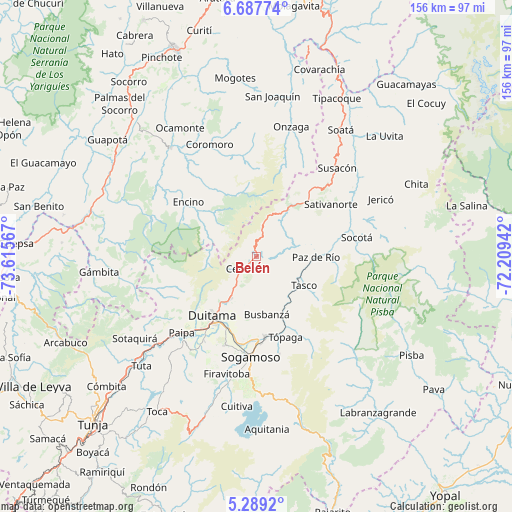
Belén GPS coordinates[2]
5° 59' 20.112" North, 72° 54' 45.144" West
| Map corner | latitude | longitude |
|---|---|---|
| Upper-left | 6.68774°, | -73.61567° |
| Center: | 5.98892°, | -72.91254° |
| Lower-right: | 5.2892°, | -72.20942° |
| Map W x H: | 155.5×155.5 km | = 96.6×96.6mi |
| max Lat: | 13.38166° ⇑40.9% North |
| Belén: | 5.98892° |
| min Lat: | ⇓59.1% South -4.21528° |
| min Long | Belén | max Long |
| -81.70636° | -72.91254° | -67.06996° |
| W 88.4%⇐ | ⇒11.6% E |
Elevation
Elevation of Belén is 2643 m = 8671 ft, and this is 1493.7 m = 4901 ft above average elevation for this country.
| Max E: |
3342 m = 10965 ft | 5.6% |
| Belén | 2643 m 8671 ft | |
| Avg. | 1149.3 m = 3771 ft | |
Min E: |
1 m = 3 ft | 94.4% |
See also: Colombia elevation on elevation.city.
Geographical zone
Belén is located in North Torrid zone (between Equator and Tropic of Cancer). Distance of Equator is 665.9 km =413.8 mi to South.| Distance of | km | miles | from Belén |
|---|---|---|---|
| North Pole | 9341.2 | 5804.4 | to North |
| Arctic Circle | 6735.3 | 4185.1 | to North |
| Tropic Cancer | 1940 | 1205.5 | to North |
| Equator | 665.9 | 413.8 | to South |


Nearby cities:
15 places around Belén: (largest is in red/bold)
• Betéitiva
14.3 km =8.9 mi,  127°
127°
• Busbanzá
17.9 km =11.1 mi,  169°
169°
• Cerinza
5.4 km =3.4 mi,  226°
226°
• Corrales
19.3 km =12 mi,  156°
156°
• Duitama
22.7 km =14.1 mi,  216°
216°
• Floresta
14.5 km =9 mi,  182°
182°
• Gámeza
23.8 km =14.8 mi,  150°
150°
• Nobsa
24.6 km =15.3 mi,  187°
187°
• Paz de Río
17.9 km =11.1 mi,  91°
91°
• Santa Rosa de Viterbo
14.9 km =9.3 mi,  211°
211°
• Sativasur
23.6 km =14.7 mi,  61°
61°
• Socha
24.5 km =15.2 mi, 87°
• Socha Viejo
21.9 km =13.6 mi, 92°
• Tasco
17.1 km =10.6 mi,  120°
120°
• Tutazá
7.9 km =4.9 mi,  52°
52°
Sources, notices
• [Note1] Compared only with cities in Colombia existing in our database
• [Src1] Map data: © OpenStreetMap contributors (CC-BY-SA)
• [Src2] Other city data from geonames.org with taken over terms of usage.
• [Src3] Geographical zone / Annual Mean Temperature by Robert A. Rohde @ Wikipedia
