Florencia geodata
Florencia (Caquetá) is a seat of a first-order administrative division; located in Colombia in America/Bogota (GMT-5) time zone. With population of 130,337 people, there are 32 cities with bigger population in this country. Compared to other cities in Colombia, 92.6% of cities are located further ↑North; 69.2% of cities are located further →East and 71.3% of cities have higher elevation than Florencia. Note1


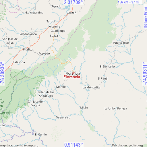
Florencia GPS coordinates[2]
1° 36' 51.768" North, 75° 36' 22.428" West
| Map corner | latitude | longitude |
|---|---|---|
| Upper-left | 2.31709°, | -76.30936° |
| Center: | 1.61438°, | -75.60623° |
| Lower-right: | 0.91143°, | -74.90311° |
| Map W x H: | 156.3×156.3 km | = 97.1×97.1mi |
| max Lat: | 13.38166° ⇑92.6% North |
| Florencia: | 1.61438° |
| min Lat: | ⇓7.4% South -4.21528° |
| min Long | Florencia | max Long |
| -81.70636° | -75.60623° | -67.06996° |
| W 30.8%⇐ | ⇒69.2% E |
Elevation
Elevation of Florencia is 270 m = 886 ft, and this is 879.3 m = 2885 ft below average elevation for this country.
| Max E: |
3342 m = 10965 ft | 71.3% |
| Avg. | 1149.3 m = 3771 ft | |
| Florencia | 270 m = 886 ft | |
Min E: |
1 m = 3 ft | 28.7% |
See also: Florencia elevation on elevation.city.
Geographical zone
Florencia is located in North Torrid zone (between Equator and Tropic of Cancer). Distance of Equator is 179.5 km =111.5 mi to South.| Distance of | km | miles | from Florencia |
|---|---|---|---|
| North Pole | 9827.6 | 6106.6 | to North |
| Arctic Circle | 7221.7 | 4487.4 | to North |
| Tropic Cancer | 2426.4 | 1507.7 | to North |
| Equator | 179.5 | 111.5 | to South |


Nearby cities:
15 places around Florencia: (largest is in red/bold)
• Acevedo
38 km =23.6 mi,  303°
303°
• Albania
43.9 km =27.3 mi,  223°
223°
• Altamira
53.8 km =33.4 mi,  338°
338°
• Belén de los Andaquíes
37.2 km =23.1 mi,  234°
234°
• El Doncello
36.4 km =22.6 mi,  78°
78°
• El Paujíl
31.2 km =19.4 mi,  99°
99°
• Guadalupe
48.6 km =30.2 mi, 339°
• La Montañita
24 km =14.9 mi,  128°
128°
• Milán
37.7 km =23.4 mi,  163°
163°
• Morelia
19.4 km =12.1 mi, 223°
• Pitalito
56.1 km =34.9 mi, 298°
• San José del Fragua
51.6 km =32.1 mi, 232°
• Suaza
45.3 km =28.1 mi,  332°
332°
• Timaná
53.7 km =33.4 mi,  317°
317°
• Valparaíso
48.1 km =29.9 mi,  193°
193°
Sources, notices
• [Note1] Compared only with cities in Colombia existing in our database
• [Src1] Map data: © OpenStreetMap contributors (CC-BY-SA)
• [Src2] Other city data from geonames.org with taken over terms of usage.
• [Src3] Geographical zone / Annual Mean Temperature by Robert A. Rohde @ Wikipedia
