El Doncello geodata
El Doncello (Caquetá) is a seat of a second-order administrative division; located in Colombia in America/Bogota (GMT-5) time zone. With population of 13,082 people, there are 245 cities with bigger population in this country. Compared to other cities in Colombia, 92.1% of cities are located further ↑North; 61.2% of cities are located further →East and 67.2% of cities have higher elevation than El Doncello. Note1


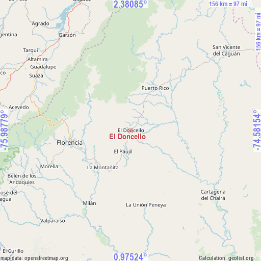
El Doncello GPS coordinates[2]
1° 40' 41.412" North, 75° 17' 4.776" West
| Map corner | latitude | longitude |
|---|---|---|
| Upper-left | 2.38085°, | -75.98779° |
| Center: | 1.67817°, | -75.28466° |
| Lower-right: | 0.97524°, | -74.58154° |
| Map W x H: | 156.3×156.3 km | = 97.1×97.1mi |
| max Lat: | 13.38166° ⇑92.1% North |
| El Doncello: | 1.67817° |
| min Lat: | ⇓7.9% South -4.21528° |
| min Long | El Doncello | max Long |
| -81.70636° | -75.28466° | -67.06996° |
| W 38.8%⇐ | ⇒61.2% E |
Elevation
Elevation of El Doncello is 357 m = 1171 ft, and this is 792.3 m = 2599 ft below average elevation for this country.
| Max E: |
3342 m = 10965 ft | 67.2% |
| Avg. | 1149.3 m = 3771 ft | |
| El Doncello | 357 m = 1171 ft | |
Min E: |
1 m = 3 ft | 32.8% |
See also: Colombia elevation on elevation.city.
Geographical zone
El Doncello is located in North Torrid zone (between Equator and Tropic of Cancer). Distance of Equator is 186.6 km =115.9 mi to South.| Distance of | km | miles | from El Doncello |
|---|---|---|---|
| North Pole | 9820.5 | 6102.2 | to North |
| Arctic Circle | 7214.6 | 4482.9 | to North |
| Tropic Cancer | 2419.3 | 1503.3 | to North |
| Equator | 186.6 | 115.9 | to South |


Nearby cities:
15 places around El Doncello: (largest is in red/bold)
• Acevedo
68.8 km =42.8 mi,  281°
281°
• Altamira
70.3 km =43.7 mi,  307°
307°
• Belén de los Andaquíes
72 km =44.7 mi,  246°
246°
• Cartagena del Chairá
62.2 km =38.6 mi,  127°
127°
• El Paujíl
13 km =8.1 mi,  202°
202°
• Florencia
36.4 km =22.6 mi,  258°
258°
• Garzón
69.1 km =42.9 mi,  326°
326°
• Guadalupe
65 km =40.4 mi, 306°
• La Montañita
27.8 km =17.3 mi,  217°
217°
• Milán
49.7 km =30.9 mi,  209°
209°
• Morelia
53.4 km =33.2 mi, 246°
• Puerto Rico
29.3 km =18.2 mi,  28°
28°
• San Vicente del Caguán
75.8 km =47.1 mi,  49°
49°
• Suaza
65.6 km =40.8 mi,  300°
300°
• Valparaíso
71.5 km =44.4 mi, 221°
Sources, notices
• [Note1] Compared only with cities in Colombia existing in our database
• [Src1] Map data: © OpenStreetMap contributors (CC-BY-SA)
• [Src2] Other city data from geonames.org with taken over terms of usage.
• [Src3] Geographical zone / Annual Mean Temperature by Robert A. Rohde @ Wikipedia
