Suaza geodata
Suaza (Huila) is a seat of a second-order administrative division; located in Colombia in America/Bogota (GMT-5) time zone. With population of 2,481 people, there are 742 cities with bigger population in this country. Compared to other cities in Colombia, 90.2% of cities are located further ↑North; 75.6% of cities are located further →East and 56.6% of cities have higher elevation than Suaza. Note1


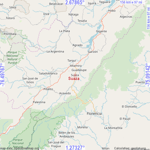
Suaza GPS coordinates[2]
1° 58' 33.996" North, 75° 47' 40.344" West
| Map corner | latitude | longitude |
|---|---|---|
| Upper-left | 2.67865°, | -76.49767° |
| Center: | 1.97611°, | -75.79454° |
| Lower-right: | 1.27327°, | -75.09142° |
| Map W x H: | 156.3×156.3 km | = 97.1×97.1mi |
| max Lat: | 13.38166° ⇑90.2% North |
| Suaza: | 1.97611° |
| min Lat: | ⇓9.8% South -4.21528° |
| min Long | Suaza | max Long |
| -81.70636° | -75.79454° | -67.06996° |
| W 24.4%⇐ | ⇒75.6% E |
Elevation
Elevation of Suaza is 944 m = 3097 ft, and this is 205.3 m = 674 ft below average elevation for this country.
| Max E: |
3342 m = 10965 ft | 56.6% |
| Avg. | 1149.3 m = 3771 ft | |
| Suaza | 944 m = 3097 ft | |
Min E: |
1 m = 3 ft | 43.4% |
See also: Colombia elevation on elevation.city.
Geographical zone
Suaza is located in North Torrid zone (between Equator and Tropic of Cancer). Distance of Equator is 219.7 km =136.5 mi to South.| Distance of | km | miles | from Suaza |
|---|---|---|---|
| North Pole | 9787.3 | 6081.5 | to North |
| Arctic Circle | 7181.5 | 4462.4 | to North |
| Tropic Cancer | 2386.2 | 1482.7 | to North |
| Equator | 219.7 | 136.5 | to South |


Nearby cities:
15 places around Suaza: (largest is in red/bold)
• Acevedo
21.8 km =13.5 mi,  209°
209°
• Agrado
31.4 km =19.5 mi,  4°
4°
• Altamira
9.7 km =6 mi, 4°
• Elías
16.6 km =10.3 mi,  283°
283°
• Florencia
45.3 km =28.1 mi,  152°
152°
• Garzón
30.7 km =19.1 mi,  37°
37°
• Guadalupe
6.9 km =4.3 mi, 38°
• Isnos
46.6 km =29 mi,  263°
263°
• La Argentina
32.1 km =19.9 mi,  320°
320°
• Oporapa
23 km =14.3 mi, 283°
• Pital
32.3 km =20.1 mi,  358°
358°
• Pitalito
31.6 km =19.6 mi,  244°
244°
• Saladoblanco
27.7 km =17.2 mi,  273°
273°
• Tarqui
15.5 km =9.6 mi,  347°
347°
• Timaná
15.2 km =9.4 mi, 268°
Sources, notices
• [Note1] Compared only with cities in Colombia existing in our database
• [Src1] Map data: © OpenStreetMap contributors (CC-BY-SA)
• [Src2] Other city data from geonames.org with taken over terms of usage.
• [Src3] Geographical zone / Annual Mean Temperature by Robert A. Rohde @ Wikipedia
