Altamira geodata
Altamira (Huila) is a seat of a second-order administrative division; located in Colombia in America/Bogota (GMT-5) time zone. With population of 2,123 people, there are 782 cities with bigger population in this country. Compared to other cities in Colombia, 89.5% of cities are located further ↑North; 74.9% of cities are located further →East and 52.4% of cities have higher elevation than Altamira. Note1


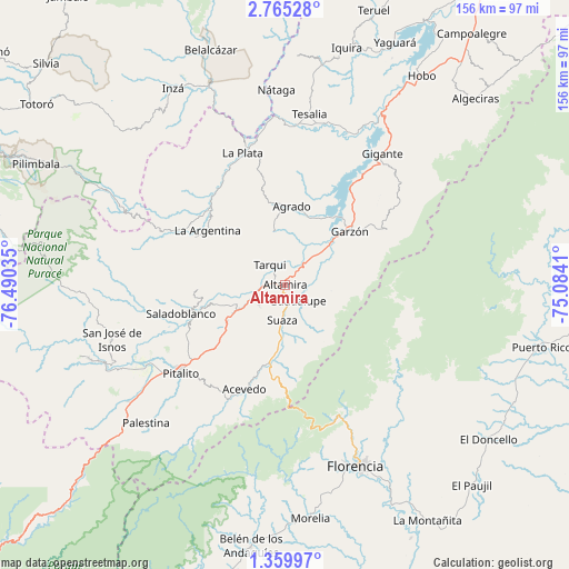
Altamira GPS coordinates[2]
2° 3' 46.008" North, 75° 47' 13.992" West
| Map corner | latitude | longitude |
|---|---|---|
| Upper-left | 2.76528°, | -76.49035° |
| Center: | 2.06278°, | -75.78722° |
| Lower-right: | 1.35997°, | -75.0841° |
| Map W x H: | 156.3×156.3 km | = 97.1×97.1mi |
| max Lat: | 13.38166° ⇑89.5% North |
| Altamira: | 2.06278° |
| min Lat: | ⇓10.5% South -4.21528° |
| min Long | Altamira | max Long |
| -81.70636° | -75.78722° | -67.06996° |
| W 25.1%⇐ | ⇒74.9% E |
Elevation
Elevation of Altamira is 1039 m = 3409 ft, and this is 110.3 m = 362 ft below average elevation for this country.
| Max E: |
3342 m = 10965 ft | 52.4% |
| Avg. | 1149.3 m = 3771 ft | |
| Altamira | 1039 m = 3409 ft | |
Min E: |
1 m = 3 ft | 47.6% |
See also: Colombia elevation on elevation.city.
Geographical zone
Altamira is located in North Torrid zone (between Equator and Tropic of Cancer). Distance of Equator is 229.4 km =142.5 mi to South.| Distance of | km | miles | from Altamira |
|---|---|---|---|
| North Pole | 9777.7 | 6075.6 | to North |
| Arctic Circle | 7171.8 | 4456.3 | to North |
| Tropic Cancer | 2376.6 | 1476.8 | to North |
| Equator | 229.4 | 142.5 | to South |


Nearby cities:
15 places around Altamira: (largest is in red/bold)
• Acevedo
30.9 km =19.2 mi,  201°
201°
• Agrado
21.7 km =13.5 mi,  4°
4°
• Elías
17.9 km =11.1 mi,  251°
251°
• Garzón
23.1 km =14.4 mi,  50°
50°
• Guadalupe
5.5 km =3.4 mi,  140°
140°
• La Argentina
26.1 km =16.2 mi,  305°
305°
• La Plata
38.6 km =24 mi,  342°
342°
• Oporapa
23.6 km =14.7 mi,  259°
259°
• Paicol
43 km =26.7 mi, 1°
• Pital
22.7 km =14.1 mi,  355°
355°
• Pitalito
37.4 km =23.2 mi,  231°
231°
• Saladoblanco
29.5 km =18.3 mi, 254°
• Suaza
9.7 km =6 mi,  184°
184°
• Tarqui
6.9 km =4.3 mi,  323°
323°
• Timaná
19 km =11.8 mi,  237°
237°
Sources, notices
• [Note1] Compared only with cities in Colombia existing in our database
• [Src1] Map data: © OpenStreetMap contributors (CC-BY-SA)
• [Src2] Other city data from geonames.org with taken over terms of usage.
• [Src3] Geographical zone / Annual Mean Temperature by Robert A. Rohde @ Wikipedia
