El Tambo geodata
El Tambo (Cauca) is a seat of a second-order administrative division; located in Colombia in America/Bogota (GMT-5) time zone. With population of 6,355 people, there are 433 cities with bigger population in this country. Compared to other cities in Colombia, 87.3% of cities are located further ↑North; 90.8% of cities are located further →East and 69.5% of cities have lower elevation than El Tambo. Note1


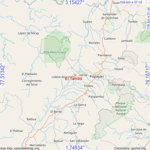
El Tambo GPS coordinates[2]
2° 27' 7.164" North, 76° 48' 37.044" West
| Map corner | latitude | longitude |
|---|---|---|
| Upper-left | 3.15427°, | -77.51342° |
| Center: | 2.45199°, | -76.81029° |
| Lower-right: | 1.74934°, | -76.10717° |
| Map W x H: | 156.2×156.2 km | = 97.1×97.1mi |
| max Lat: | 13.38166° ⇑87.3% North |
| El Tambo: | 2.45199° |
| min Lat: | ⇓12.7% South -4.21528° |
| min Long | El Tambo | max Long |
| -81.70636° | -76.81029° | -67.06996° |
| W 9.2%⇐ | ⇒90.8% E |
Elevation
Elevation of El Tambo is 1719 m = 5640 ft, and this is 569.7 m = 1869 ft above average elevation for this country.
| Max E: |
3342 m = 10965 ft | 30.5% |
| El Tambo | 1719 m 5640 ft | |
| Avg. | 1149.3 m = 3771 ft | |
Min E: |
1 m = 3 ft | 69.5% |
See also: Colombia elevation on elevation.city.
Geographical zone
El Tambo is located in North Torrid zone (between Equator and Tropic of Cancer). Distance of Equator is 272.6 km =169.4 mi to South.| Distance of | km | miles | from El Tambo |
|---|---|---|---|
| North Pole | 9734.4 | 6048.7 | to North |
| Arctic Circle | 7128.5 | 4429.4 | to North |
| Tropic Cancer | 2333.3 | 1449.8 | to North |
| Equator | 272.6 | 169.4 | to South |


Nearby cities:
15 places around El Tambo: (largest is in red/bold)
• Cajibío
32.7 km =20.3 mi,  54°
54°
• Coconuco
37 km =23 mi,  109°
109°
• El Bordo
41.9 km =26 mi,  207°
207°
• La Sierra
30.9 km =19.2 mi,  170°
170°
• La Vega
50.2 km =31.2 mi,  176°
176°
• López
2.4 km =1.5 mi,  151°
151°
• Morales
39.3 km =24.4 mi,  31°
31°
• Paispamba
31.2 km =19.4 mi,  134°
134°
• Piendamo
37.4 km =23.2 mi,  56°
56°
• Popayán
22 km =13.7 mi,  93°
93°
• Rosas
22.6 km =14 mi,  159°
159°
• Sucre
47.7 km =29.6 mi,  195°
195°
• Timbío
18.1 km =11.2 mi, 128°
• Totoró
45.9 km =28.5 mi,  81°
81°
• Villa Rica
8.2 km =5.1 mi,  327°
327°
Sources, notices
• [Note1] Compared only with cities in Colombia existing in our database
• [Src1] Map data: © OpenStreetMap contributors (CC-BY-SA)
• [Src2] Other city data from geonames.org with taken over terms of usage.
• [Src3] Geographical zone / Annual Mean Temperature by Robert A. Rohde @ Wikipedia
