La Vega geodata
La Vega (Cauca) is a seat of a second-order administrative division; located in Colombia in America/Bogota (GMT-5) time zone. With population of 3,469 people, there are 639 cities with bigger population in this country. Compared to other cities in Colombia, 90.1% of cities are located further ↑North; 90.4% of cities are located further →East and 89.9% of cities have lower elevation than La Vega. Note1


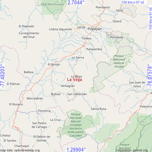
La Vega GPS coordinates[2]
2° 0' 6.732" North, 76° 46' 44.04" West
| Map corner | latitude | longitude |
|---|---|---|
| Upper-left | 2.7044°, | -77.48203° |
| Center: | 2.00187°, | -76.7789° |
| Lower-right: | 1.29904°, | -76.07578° |
| Map W x H: | 156.3×156.3 km | = 97.1×97.1mi |
| max Lat: | 13.38166° ⇑90.1% North |
| La Vega: | 2.00187° |
| min Lat: | ⇓9.9% South -4.21528° |
| min Long | La Vega | max Long |
| -81.70636° | -76.7789° | -67.06996° |
| W 9.6%⇐ | ⇒90.4% E |
Elevation
Elevation of La Vega is 2543 m = 8343 ft, and this is 1393.7 m = 4573 ft above average elevation for this country.
| Max E: |
3342 m = 10965 ft | 10.1% |
| La Vega | 2543 m 8343 ft | |
| Avg. | 1149.3 m = 3771 ft | |
Min E: |
1 m = 3 ft | 89.9% |
See also: Colombia elevation on elevation.city.
Geographical zone
La Vega is located in North Torrid zone (between Equator and Tropic of Cancer). Distance of Equator is 222.6 km =138.3 mi to South.| Distance of | km | miles | from La Vega |
|---|---|---|---|
| North Pole | 9784.5 | 6079.8 | to North |
| Arctic Circle | 7178.6 | 4460.6 | to North |
| Tropic Cancer | 2383.3 | 1480.9 | to North |
| Equator | 222.6 | 138.3 | to South |


Nearby cities:
15 places around La Vega: (largest is in red/bold)
• Almaguer
12.8 km =8 mi,  221°
221°
• Bolívar
27.7 km =17.2 mi,  229°
229°
• El Bordo
26 km =16.2 mi,  299°
299°
• Florencia
48.2 km =30 mi, 222°
• Génova
48 km =29.8 mi,  213°
213°
• La Sierra
19.7 km =12.2 mi,  5°
5°
• López
48 km =29.8 mi,  357°
357°
• Paispamba
33.7 km =20.9 mi,  33°
33°
• Patía
31.3 km =19.4 mi,  283°
283°
• Rosas
29.1 km =18.1 mi, 8°
• San Pablo
45 km =28 mi, 215°
• San Sebastián
18.2 km =11.3 mi,  177°
177°
• Santa Rosa
40.3 km =25 mi,  145°
145°
• Sucre
16.7 km =10.4 mi, 283°
• Timbío
40.2 km =25 mi,  15°
15°
Sources, notices
• [Note1] Compared only with cities in Colombia existing in our database
• [Src1] Map data: © OpenStreetMap contributors (CC-BY-SA)
• [Src2] Other city data from geonames.org with taken over terms of usage.
• [Src3] Geographical zone / Annual Mean Temperature by Robert A. Rohde @ Wikipedia
