El Bordo geodata
El Bordo (Cauca) is a seat of a second-order administrative division; located in Colombia in America/Bogota (GMT-5) time zone. With population of 12,072 people, there are 255 cities with bigger population in this country. Compared to other cities in Colombia, 89.2% of cities are located further ↑North; 92.4% of cities are located further →East and 54.1% of cities have higher elevation than El Bordo. Note1


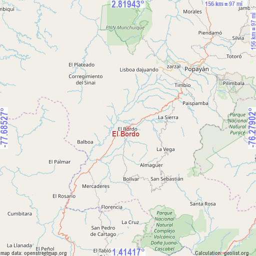
El Bordo GPS coordinates[2]
2° 7' 1.056" North, 76° 58' 55.704" West
| Map corner | latitude | longitude |
|---|---|---|
| Upper-left | 2.81943°, | -77.68527° |
| Center: | 2.11696°, | -76.98214° |
| Lower-right: | 1.41417°, | -76.27902° |
| Map W x H: | 156.3×156.3 km | = 97.1×97.1mi |
| max Lat: | 13.38166° ⇑89.2% North |
| El Bordo: | 2.11696° |
| min Lat: | ⇓10.8% South -4.21528° |
| min Long | El Bordo | max Long |
| -81.70636° | -76.98214° | -67.06996° |
| W 7.6%⇐ | ⇒92.4% E |
Elevation
Elevation of El Bordo is 990 m = 3248 ft, and this is 159.3 m = 523 ft below average elevation for this country.
| Max E: |
3342 m = 10965 ft | 54.1% |
| Avg. | 1149.3 m = 3771 ft | |
| El Bordo | 990 m = 3248 ft | |
Min E: |
1 m = 3 ft | 45.9% |
See also: Colombia elevation on elevation.city.
Geographical zone
El Bordo is located in North Torrid zone (between Equator and Tropic of Cancer). Distance of Equator is 235.4 km =146.3 mi to South.| Distance of | km | miles | from El Bordo |
|---|---|---|---|
| North Pole | 9771.7 | 6071.9 | to North |
| Arctic Circle | 7165.8 | 4452.6 | to North |
| Tropic Cancer | 2370.5 | 1473 | to North |
| Equator | 235.4 | 146.3 | to South |


Nearby cities:
15 places around El Bordo: (largest is in red/bold)
• Almaguer
26.6 km =16.5 mi,  147°
147°
• Argelia
33.4 km =20.8 mi,  297°
297°
• Balboa
27.3 km =17 mi,  252°
252°
• Bolívar
30.8 km =19.1 mi,  177°
177°
• El Tambo
41.9 km =26 mi,  27°
27°
• La Sierra
25.3 km =15.7 mi,  74°
74°
• La Vega
26 km =16.2 mi,  119°
119°
• Leiva
41.3 km =25.7 mi,  240°
240°
• López
40.6 km =25.2 mi, 29°
• Mercaderes
40.8 km =25.4 mi,  210°
210°
• Patía
9.5 km =5.9 mi, 235°
• Rosas
31.3 km =19.4 mi,  59°
59°
• San Sebastián
38.8 km =24.1 mi,  142°
142°
• Sucre
10.9 km =6.8 mi, 143°
• Timbío
42.1 km =26.2 mi,  52°
52°
Sources, notices
• [Note1] Compared only with cities in Colombia existing in our database
• [Src1] Map data: © OpenStreetMap contributors (CC-BY-SA)
• [Src2] Other city data from geonames.org with taken over terms of usage.
• [Src3] Geographical zone / Annual Mean Temperature by Robert A. Rohde @ Wikipedia
