Onzaga geodata
Onzaga (Santander) is a seat of a second-order administrative division; located in Colombia in America/Bogota (GMT-5) time zone. With population of 1,393 people, there are 885 cities with bigger population in this country. Compared to other cities in Colombia, 65.8% of cities are located further ↓South; 90.2% of cities are located further ←West and 77.7% of cities have lower elevation than Onzaga. Note1


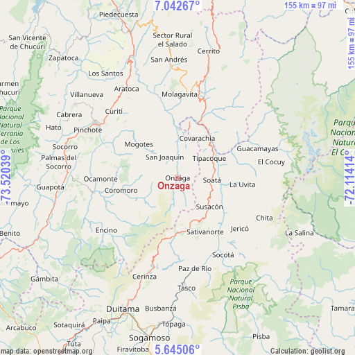
Onzaga GPS coordinates[2]
6° 20' 39.624" North, 72° 49' 2.136" West
| Map corner | latitude | longitude |
|---|---|---|
| Upper-left | 7.04267°, | -73.52039° |
| Center: | 6.34434°, | -72.81726° |
| Lower-right: | 5.64506°, | -72.11414° |
| Map W x H: | 155.4×155.4 km | = 96.6×96.6mi |
| max Lat: | 13.38166° ⇑34.2% North |
| Onzaga: | 6.34434° |
| min Lat: | ⇓65.8% South -4.21528° |
| min Long | Onzaga | max Long |
| -81.70636° | -72.81726° | -67.06996° |
| W 90.2%⇐ | ⇒9.8% E |
Elevation
Elevation of Onzaga is 1955 m = 6414 ft, and this is 805.7 m = 2643 ft above average elevation for this country.
| Max E: |
3342 m = 10965 ft | 22.3% |
| Onzaga | 1955 m 6414 ft | |
| Avg. | 1149.3 m = 3771 ft | |
Min E: |
1 m = 3 ft | 77.7% |
See also: Colombia elevation on elevation.city.
Geographical zone
Onzaga is located in North Torrid zone (between Equator and Tropic of Cancer). Distance of Equator is 705.4 km =438.3 mi to South.| Distance of | km | miles | from Onzaga |
|---|---|---|---|
| North Pole | 9301.6 | 5779.7 | to North |
| Arctic Circle | 6695.7 | 4160.5 | to North |
| Tropic Cancer | 1900.5 | 1180.9 | to North |
| Equator | 705.4 | 438.3 | to South |


Nearby cities:
15 places around Onzaga: (largest is in red/bold)
• Boavita
25.7 km =16 mi,  93°
93°
• Capitanejo
24.5 km =15.2 mi,  33°
33°
• Coromoro
25.3 km =15.7 mi,  257°
257°
• Covarachía
20.2 km =12.6 mi, 27°
• El Peñón
22.9 km =14.2 mi,  355°
355°
• La Uvita
28.2 km =17.5 mi,  95°
95°
• Macaravita
30.6 km =19 mi,  54°
54°
• Mogotes
22.4 km =13.9 mi,  310°
310°
• San Joaquín
11 km =6.8 mi,  329°
329°
• San Mateo
29.9 km =18.6 mi,  77°
77°
• Sativanorte
26.5 km =16.5 mi,  153°
153°
• Sativasur
30.1 km =18.7 mi,  160°
160°
• Soatá
14.9 km =9.3 mi, 94°
• Susacón
19 km =11.8 mi,  132°
132°
• Tipacoque
16.2 km =10.1 mi,  58°
58°
Sources, notices
• [Note1] Compared only with cities in Colombia existing in our database
• [Src1] Map data: © OpenStreetMap contributors (CC-BY-SA)
• [Src2] Other city data from geonames.org with taken over terms of usage.
• [Src3] Geographical zone / Annual Mean Temperature by Robert A. Rohde @ Wikipedia
