Mogotes geodata
Mogotes (Santander) is a seat of a second-order administrative division; located in Colombia in America/Bogota (GMT-5) time zone. With population of 3,438 people, there are 643 cities with bigger population in this country. Compared to other cities in Colombia, 67.9% of cities are located further ↓South; 87.3% of cities are located further ←West and 68.2% of cities have lower elevation than Mogotes. Note1


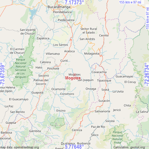
Mogotes GPS coordinates[2]
6° 28' 32.124" North, 72° 58' 13.656" West
| Map corner | latitude | longitude |
|---|---|---|
| Upper-left | 7.17373°, | -73.67359° |
| Center: | 6.47559°, | -72.97046° |
| Lower-right: | 5.77648°, | -72.26734° |
| Map W x H: | 155.4×155.4 km | = 96.6×96.6mi |
| max Lat: | 13.38166° ⇑32.1% North |
| Mogotes: | 6.47559° |
| min Lat: | ⇓67.9% South -4.21528° |
| min Long | Mogotes | max Long |
| -81.70636° | -72.97046° | -67.06996° |
| W 87.3%⇐ | ⇒12.7% E |
Elevation
Elevation of Mogotes is 1681 m = 5515 ft, and this is 531.7 m = 1744 ft above average elevation for this country.
| Max E: |
3342 m = 10965 ft | 31.8% |
| Mogotes | 1681 m 5515 ft | |
| Avg. | 1149.3 m = 3771 ft | |
Min E: |
1 m = 3 ft | 68.2% |
See also: Colombia elevation on elevation.city.
Geographical zone
Mogotes is located in North Torrid zone (between Equator and Tropic of Cancer). Distance of Equator is 720 km =447.4 mi to South.| Distance of | km | miles | from Mogotes |
|---|---|---|---|
| North Pole | 9287 | 5770.7 | to North |
| Arctic Circle | 6681.2 | 4151.5 | to North |
| Tropic Cancer | 1885.9 | 1171.8 | to North |
| Equator | 720 | 447.4 | to South |


Nearby cities:
15 places around Mogotes: (largest is in red/bold)
• Aratoca
24.9 km =15.5 mi,  347°
347°
• Capitanejo
30.9 km =19.2 mi,  78°
78°
• Charalá
28.8 km =17.9 mi,  222°
222°
• Coromoro
21.5 km =13.4 mi,  200°
200°
• Covarachía
26.4 km =16.4 mi, 82°
• Curití
18 km =11.2 mi,  323°
323°
• El Peñón
17.3 km =10.7 mi,  61°
61°
• Molagavita
28.3 km =17.6 mi,  39°
39°
• Ocamonte
22.5 km =14 mi,  228°
228°
• Onzaga
22.4 km =13.9 mi,  130°
130°
• Pinchote
23.3 km =14.5 mi,  285°
285°
• Páramo
23 km =14.3 mi,  253°
253°
• San Gil
20.6 km =12.8 mi,  296°
296°
• San Joaquín
12.4 km =7.7 mi,  114°
114°
• Valle de San José
19.4 km =12.1 mi,  260°
260°
Sources, notices
• [Note1] Compared only with cities in Colombia existing in our database
• [Src1] Map data: © OpenStreetMap contributors (CC-BY-SA)
• [Src2] Other city data from geonames.org with taken over terms of usage.
• [Src3] Geographical zone / Annual Mean Temperature by Robert A. Rohde @ Wikipedia
