San Joaquín geodata
San Joaquín (Santander) is a seat of a second-order administrative division; located in Colombia in America/Bogota (GMT-5) time zone. With population of 844 people, there are 970 cities with bigger population in this country. Compared to other cities in Colombia, 66.9% of cities are located further ↓South; 89.2% of cities are located further ←West and 79.1% of cities have lower elevation than San Joaquín. Note1


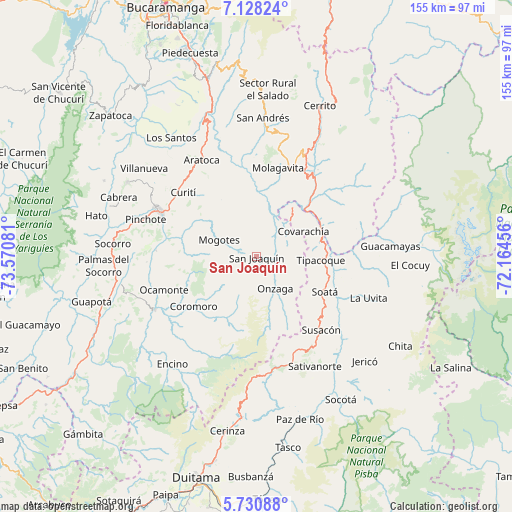
San Joaquín GPS coordinates[2]
6° 25' 48.144" North, 72° 52' 3.648" West
| Map corner | latitude | longitude |
|---|---|---|
| Upper-left | 7.12824°, | -73.57081° |
| Center: | 6.43004°, | -72.86768° |
| Lower-right: | 5.73088°, | -72.16456° |
| Map W x H: | 155.4×155.4 km | = 96.6×96.6mi |
| max Lat: | 13.38166° ⇑33.1% North |
| San Joaquín: | 6.43004° |
| min Lat: | ⇓66.9% South -4.21528° |
| min Long | San Joaquín | max Long |
| -81.70636° | -72.86768° | -67.06996° |
| W 89.2%⇐ | ⇒10.8% E |
Elevation
Elevation of San Joaquín is 2004 m = 6575 ft, and this is 854.7 m = 2804 ft above average elevation for this country.
| Max E: |
3342 m = 10965 ft | 20.9% |
| San Joaquín | 2004 m 6575 ft | |
| Avg. | 1149.3 m = 3771 ft | |
Min E: |
1 m = 3 ft | 79.1% |
See also: Colombia elevation on elevation.city.
Geographical zone
San Joaquín is located in North Torrid zone (between Equator and Tropic of Cancer). Distance of Equator is 715 km =444.3 mi to South.| Distance of | km | miles | from San Joaquín |
|---|---|---|---|
| North Pole | 9292.1 | 5773.8 | to North |
| Arctic Circle | 6686.2 | 4154.6 | to North |
| Tropic Cancer | 1891 | 1175 | to North |
| Equator | 715 | 444.3 | to South |


Nearby cities:
15 places around San Joaquín: (largest is in red/bold)
• Capitanejo
21.9 km =13.6 mi,  59°
59°
• Coromoro
24.3 km =15.1 mi,  231°
231°
• Covarachía
17.1 km =10.6 mi, 60°
• Curití
29.5 km =18.3 mi,  311°
311°
• El Peñón
13.9 km =8.6 mi,  15°
15°
• Mogotes
12.4 km =7.7 mi,  294°
294°
• Molagavita
27.8 km =17.3 mi,  13°
13°
• Ocamonte
29.8 km =18.5 mi,  250°
250°
• Onzaga
11 km =6.8 mi,  149°
149°
• San José de Miranda
29.4 km =18.3 mi,  30°
30°
• San Miguel
29.4 km =18.3 mi, 56°
• Soatá
23.1 km =14.4 mi,  117°
117°
• Susacón
29.7 km =18.5 mi,  138°
138°
• Tipacoque
19.5 km =12.1 mi,  93°
93°
• Valle de San José
30.5 km =19 mi,  273°
273°
Sources, notices
• [Note1] Compared only with cities in Colombia existing in our database
• [Src1] Map data: © OpenStreetMap contributors (CC-BY-SA)
• [Src2] Other city data from geonames.org with taken over terms of usage.
• [Src3] Geographical zone / Annual Mean Temperature by Robert A. Rohde @ Wikipedia
