Dagua geodata
Dagua (Valle del Cauca) is a seat of a second-order administrative division; located in Colombia in America/Bogota (GMT-5) time zone. With population of 12,320 people, there are 252 cities with bigger population in this country. Compared to other cities in Colombia, 80.6% of cities are located further ↑North; 89.6% of cities are located further →East and 58.2% of cities have higher elevation than Dagua. Note1


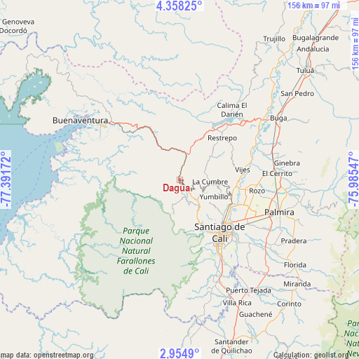
Dagua GPS coordinates[2]
3° 39' 24.66" North, 76° 41' 18.924" West
| Map corner | latitude | longitude |
|---|---|---|
| Upper-left | 4.35825°, | -77.39172° |
| Center: | 3.65685°, | -76.68859° |
| Lower-right: | 2.9549°, | -75.98547° |
| Map W x H: | 156×156 km | = 96.9×96.9mi |
| max Lat: | 13.38166° ⇑80.6% North |
| Dagua: | 3.65685° |
| min Lat: | ⇓19.4% South -4.21528° |
| min Long | Dagua | max Long |
| -81.70636° | -76.68859° | -67.06996° |
| W 10.4%⇐ | ⇒89.6% E |
Elevation
Elevation of Dagua is 882 m = 2894 ft, and this is 267.3 m = 877 ft below average elevation for this country.
| Max E: |
3342 m = 10965 ft | 58.2% |
| Avg. | 1149.3 m = 3771 ft | |
| Dagua | 882 m = 2894 ft | |
Min E: |
1 m = 3 ft | 41.8% |
See also: Colombia elevation on elevation.city.
Geographical zone
Dagua is located in North Torrid zone (between Equator and Tropic of Cancer). Distance of Equator is 406.6 km =252.6 mi to South.| Distance of | km | miles | from Dagua |
|---|---|---|---|
| North Pole | 9600.5 | 5965.5 | to North |
| Arctic Circle | 6994.6 | 4346.2 | to North |
| Tropic Cancer | 2199.3 | 1366.6 | to North |
| Equator | 406.6 | 252.6 | to South |


Nearby cities:
15 places around Dagua: (largest is in red/bold)
• Buenaventura
35.5 km =22.1 mi,  256°
256°
• Buenaventura
45.4 km =28.2 mi,  303°
303°
• Cali
30.6 km =19 mi,  142°
142°
• Calimita
35.7 km =22.2 mi,  35°
35°
• Candelaria
46.9 km =29.1 mi,  126°
126°
• Darien
38 km =23.6 mi, 36°
• El Cerrito
41.7 km =25.9 mi,  85°
85°
• Guacarí
41.2 km =25.6 mi,  73°
73°
• Jamundí
47.2 km =29.3 mi,  158°
158°
• La Cumbre
13.2 km =8.2 mi, 93°
• Palmira
44.7 km =27.8 mi,  106°
106°
• Restrepo
26 km =16.2 mi,  45°
45°
• Vijes
27.7 km =17.2 mi,  80°
80°
• Yotoco
40.7 km =25.3 mi,  56°
56°
• Yumbo
23.4 km =14.5 mi, 110°
Sources, notices
• [Note1] Compared only with cities in Colombia existing in our database
• [Src1] Map data: © OpenStreetMap contributors (CC-BY-SA)
• [Src2] Other city data from geonames.org with taken over terms of usage.
• [Src3] Geographical zone / Annual Mean Temperature by Robert A. Rohde @ Wikipedia
