Buenaventura geodata
Buenaventura (Valle del Cauca) is a seat of a second-order administrative division; located in Colombia in America/Bogota (GMT-5) time zone. With population of 240,387 people, there are 25 cities with bigger population in this country. Compared to other cities in Colombia, 79% of cities are located further ↑North; 92.8% of cities are located further →East and 93.2% of cities have higher elevation than Buenaventura. Note1


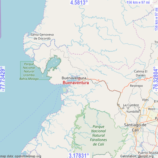
Buenaventura GPS coordinates[2]
3° 52' 48.36" North, 77° 1' 52.176" West
| Map corner | latitude | longitude |
|---|---|---|
| Upper-left | 4.5813°, | -77.73429° |
| Center: | 3.8801°, | -77.03116° |
| Lower-right: | 3.17831°, | -76.32804° |
| Map W x H: | 156×156 km | = 96.9×96.9mi |
| max Lat: | 13.38166° ⇑79% North |
| Buenaventura: | 3.8801° |
| min Lat: | ⇓21% South -4.21528° |
| min Long | Buenaventura | max Long |
| -81.70636° | -77.03116° | -67.06996° |
| W 7.2%⇐ | ⇒92.8% E |
Elevation
Elevation of Buenaventura is 19 m = 62 ft, and this is 1130.3 m = 3708 ft below average elevation for this country.
| Max E: |
3342 m = 10965 ft | 93.2% |
| Avg. | 1149.3 m = 3771 ft | |
| Buenaventura | 19 m = 62 ft | |
Min E: |
1 m = 3 ft | 6.8% |
See also: Buenaventura elevation on elevation.city.
Geographical zone
Buenaventura is located in North Torrid zone (between Equator and Tropic of Cancer). Distance of Equator is 431.4 km =268.1 mi to South.| Distance of | km | miles | from Buenaventura |
|---|---|---|---|
| North Pole | 9575.6 | 5950 | to North |
| Arctic Circle | 6969.7 | 4330.8 | to North |
| Tropic Cancer | 2174.5 | 1351.2 | to North |
| Equator | 431.4 | 268.1 | to South |


Nearby cities:
15 places around Buenaventura: (largest is in red/bold)
• Buenaventura
33.2 km =20.6 mi,  174°
174°
• Cali
74.9 km =46.5 mi,  131°
131°
• Calimita
59.1 km =36.7 mi,  86°
86°
• Dagua
45.4 km =28.2 mi,  123°
123°
• Darien
60.9 km =37.8 mi,  84°
84°
• El Cerrito
82.5 km =51.3 mi,  105°
105°
• Ginebra
86.6 km =53.8 mi,  101°
101°
• Guacarí
78.5 km =48.8 mi, 99°
• Guadalajara de Buga
81.4 km =50.6 mi, 88°
• La Cumbre
57.2 km =35.5 mi, 116°
• Restrepo
56.8 km =35.3 mi, 96°
• Santa Genoveva de Docordó
56.1 km =34.9 mi,  318°
318°
• Vijes
68.4 km =42.5 mi, 107°
• Yotoco
71.9 km =44.7 mi, 91°
• Yumbo
68.4 km =42.5 mi, 118°
Sources, notices
• [Note1] Compared only with cities in Colombia existing in our database
• [Src1] Map data: © OpenStreetMap contributors (CC-BY-SA)
• [Src2] Other city data from geonames.org with taken over terms of usage.
• [Src3] Geographical zone / Annual Mean Temperature by Robert A. Rohde @ Wikipedia
