Buenaventura geodata
Buenaventura (Valle del Cauca) is a populated place; located in Colombia in America/Bogota (GMT-5) time zone. With population of 24,842 people, there are 148 cities with bigger population in this country. Compared to other cities in Colombia, 80.9% of cities are located further ↑North; 92.5% of cities are located further →East and 76% of cities have higher elevation than Buenaventura. Note1


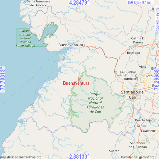
Buenaventura GPS coordinates[2]
3° 34' 59.988" North, 77° 0' 0" West
| Map corner | latitude | longitude |
|---|---|---|
| Upper-left | 4.28479°, | -77.70313° |
| Center: | 3.58333°, | -77° |
| Lower-right: | 2.88133°, | -76.29688° |
| Map W x H: | 156.1×156.1 km | = 97×97mi |
| max Lat: | 13.38166° ⇑80.9% North |
| Buenaventura: | 3.58333° |
| min Lat: | ⇓19.1% South -4.21528° |
| min Long | Buenaventura | max Long |
| -81.70636° | -77° | -67.06996° |
| W 7.5%⇐ | ⇒92.5% E |
Elevation
Elevation of Buenaventura is 169 m = 554 ft, and this is 980.3 m = 3216 ft below average elevation for this country.
| Max E: |
3342 m = 10965 ft | 76% |
| Avg. | 1149.3 m = 3771 ft | |
| Buenaventura | 169 m = 554 ft | |
Min E: |
1 m = 3 ft | 24% |
See also: Colombia elevation on elevation.city.
Geographical zone
Buenaventura is located in North Torrid zone (between Equator and Tropic of Cancer). Distance of Equator is 398.4 km =247.6 mi to South.| Distance of | km | miles | from Buenaventura |
|---|---|---|---|
| North Pole | 9608.6 | 5970.5 | to North |
| Arctic Circle | 7002.7 | 4351.3 | to North |
| Tropic Cancer | 2207.5 | 1371.7 | to North |
| Equator | 398.4 | 247.6 | to South |


Nearby cities:
15 places around Buenaventura: (largest is in red/bold)
• Buenaventura
33.2 km =20.6 mi,  354°
354°
• Buenos Aires
74.5 km =46.3 mi,  148°
148°
• Cali
55.4 km =34.4 mi,  107°
107°
• Calimita
66.7 km =41.4 mi,  56°
56°
• Candelaria
75 km =46.6 mi, 105°
• Dagua
35.5 km =22.1 mi,  76°
76°
• Darien
69 km =42.9 mi, 55°
• Jamundí
62.9 km =39.1 mi,  124°
124°
• La Cumbre
48.3 km =30 mi, 81°
• Puerto Tejada
75.7 km =47 mi, 121°
• Restrepo
59.3 km =36.8 mi, 63°
• Vijes
63.2 km =39.3 mi, 78°
• Villa Rica
75 km =46.6 mi,  127°
127°
• Yotoco
75 km =46.6 mi,  65°
65°
• Yumbo
56.4 km =35 mi,  90°
90°
Sources, notices
• [Note1] Compared only with cities in Colombia existing in our database
• [Src1] Map data: © OpenStreetMap contributors (CC-BY-SA)
• [Src2] Other city data from geonames.org with taken over terms of usage.
• [Src3] Geographical zone / Annual Mean Temperature by Robert A. Rohde @ Wikipedia
