Granada geodata
Granada (Cundinamarca) is a populated place; located in Colombia in America/Bogota (GMT-5) time zone. With population of 1,100 people, there are 933 cities with bigger population in this country. Compared to other cities in Colombia, 60.7% of cities are located further ↑North; 55.5% of cities are located further ←West and 64.6% of cities have lower elevation than Granada. Note1


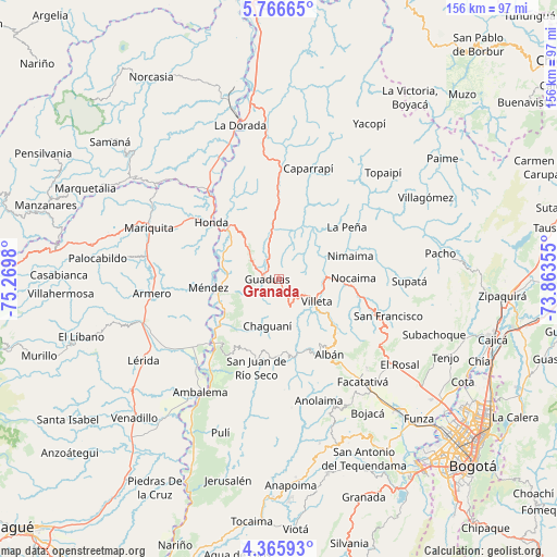
Granada GPS coordinates[2]
5° 4' 0.012" North, 74° 34' 0.012" West
| Map corner | latitude | longitude |
|---|---|---|
| Upper-left | 5.76665°, | -75.2698° |
| Center: | 5.06667°, | -74.56667° |
| Lower-right: | 4.36593°, | -73.86355° |
| Map W x H: | 155.7×155.7 km | = 96.7×96.7mi |
| max Lat: | 13.38166° ⇑60.7% North |
| Granada: | 5.06667° |
| min Lat: | ⇓39.3% South -4.21528° |
| min Long | Granada | max Long |
| -81.70636° | -74.56667° | -67.06996° |
| W 55.5%⇐ | ⇒44.5% E |
Elevation
Elevation of Granada is 1584 m = 5197 ft, and this is 434.7 m = 1426 ft above average elevation for this country.
| Max E: |
3342 m = 10965 ft | 35.4% |
| Granada | 1584 m 5197 ft | |
| Avg. | 1149.3 m = 3771 ft | |
Min E: |
1 m = 3 ft | 64.6% |
See also: Colombia elevation on elevation.city.
Geographical zone
Granada is located in North Torrid zone (between Equator and Tropic of Cancer). Distance of Equator is 563.4 km =350.1 mi to South.| Distance of | km | miles | from Granada |
|---|---|---|---|
| North Pole | 9443.7 | 5868 | to North |
| Arctic Circle | 6837.8 | 4248.8 | to North |
| Tropic Cancer | 2042.6 | 1269.2 | to North |
| Equator | 563.4 | 350.1 | to South |


Nearby cities:
15 places around Granada: (largest is in red/bold)
• Bituima
21.8 km =13.5 mi,  171°
171°
• Cachipay
22.2 km =13.8 mi,  0°
0°
• Chaguaní
13.5 km =8.4 mi,  192°
192°
• Guaduas
3.1 km =1.9 mi,  270°
270°
• Guayabal de Síquima
23.7 km =14.7 mi,  152°
152°
• Honda
24.5 km =15.2 mi,  310°
310°
• La Peña
24.1 km =15 mi,  52°
52°
• Nimaima
21.2 km =13.2 mi,  71°
71°
• Nocaima
20.2 km =12.6 mi,  89°
89°
• Puerto Bogotá
23.2 km =14.4 mi, 309°
• Quebradanegra
11.2 km =7 mi,  59°
59°
• Sasaima
18.3 km =11.4 mi,  127°
127°
• Vianí
21.4 km =13.3 mi,  178°
178°
• Villeta
12.3 km =7.6 mi,  121°
121°
• Útica
16.4 km =10.2 mi,  35°
35°
Sources, notices
• [Note1] Compared only with cities in Colombia existing in our database
• [Src1] Map data: © OpenStreetMap contributors (CC-BY-SA)
• [Src2] Other city data from geonames.org with taken over terms of usage.
• [Src3] Geographical zone / Annual Mean Temperature by Robert A. Rohde @ Wikipedia
