Socha geodata
Socha (Boyacá) is a seat of a second-order administrative division; located in Colombia in America/Bogota (GMT-5) time zone. In our database, there are 1053 cities with bigger population. Compared to other cities in Colombia, 59.4% of cities are located further ↓South; 92.9% of cities are located further ←West and 95.5% of cities have lower elevation than Socha. Note1


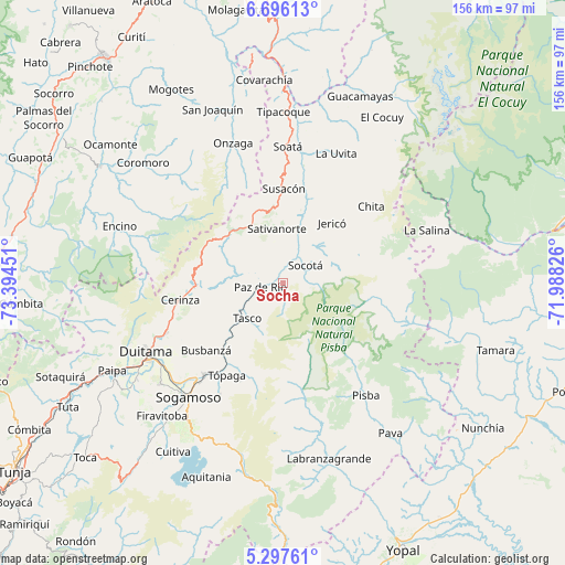
Socha GPS coordinates[2]
5° 59' 50.352" North, 72° 41' 28.968" West
| Map corner | latitude | longitude |
|---|---|---|
| Upper-left | 6.69613°, | -73.39451° |
| Center: | 5.99732°, | -72.69138° |
| Lower-right: | 5.29761°, | -71.98826° |
| Map W x H: | 155.5×155.5 km | = 96.6×96.6mi |
| max Lat: | 13.38166° ⇑40.6% North |
| Socha: | 5.99732° |
| min Lat: | ⇓59.4% South -4.21528° |
| min Long | Socha | max Long |
| -81.70636° | -72.69138° | -67.06996° |
| W 92.9%⇐ | ⇒7.1% E |
Elevation
Elevation of Socha is 2685 m = 8809 ft, and this is 1535.7 m = 5038 ft above average elevation for this country.
| Max E: |
3342 m = 10965 ft | 4.5% |
| Socha | 2685 m 8809 ft | |
| Avg. | 1149.3 m = 3771 ft | |
Min E: |
1 m = 3 ft | 95.5% |
See also: Colombia elevation on elevation.city.
Geographical zone
Socha is located in North Torrid zone (between Equator and Tropic of Cancer). Distance of Equator is 666.8 km =414.3 mi to South.| Distance of | km | miles | from Socha |
|---|---|---|---|
| North Pole | 9340.2 | 5803.7 | to North |
| Arctic Circle | 6734.3 | 4184.5 | to North |
| Tropic Cancer | 1939.1 | 1204.9 | to North |
| Equator | 666.8 | 414.3 | to South |


Nearby cities:
15 places around Socha: (largest is in red/bold)
• Belén
24.5 km =15.2 mi,  267°
267°
• Betéitiva
16.2 km =10.1 mi,  233°
233°
• Busbanzá
28.3 km =17.6 mi, 228°
• Cerinza
28.7 km =17.8 mi,  260°
260°
• Corrales
25.1 km =15.6 mi,  222°
222°
• Gámeza
25.1 km =15.6 mi,  210°
210°
• Jericó
21.2 km =13.2 mi,  38°
38°
• Paz de Río
6.7 km =4.2 mi, 257°
• Sativanorte
15.1 km =9.4 mi,  352°
352°
• Sativasur
10.9 km =6.8 mi,  340°
340°
• Socha Viejo
3.1 km =1.9 mi,  236°
236°
• Socotá
7.8 km =4.8 mi,  52°
52°
• Susacón
25.8 km =16 mi,  0°
0°
• Tasco
13.8 km =8.6 mi, 225°
• Tutazá
18.7 km =11.6 mi,  282°
282°
Sources, notices
• [Note1] Compared only with cities in Colombia existing in our database
• [Src1] Map data: © OpenStreetMap contributors (CC-BY-SA)
• [Src2] Other city data from geonames.org with taken over terms of usage.
• [Src3] Geographical zone / Annual Mean Temperature by Robert A. Rohde @ Wikipedia
