Sativasur geodata
Sativasur (Boyacá) is a seat of a second-order administrative division; located in Colombia in America/Bogota (GMT-5) time zone. With population of 579 people, there are 1018 cities with bigger population in this country. Compared to other cities in Colombia, 60.9% of cities are located further ↓South; 92% of cities are located further ←West and 94.5% of cities have lower elevation than Sativasur. Note1


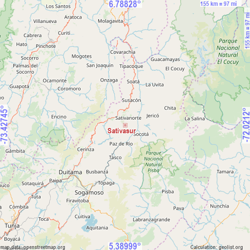
Sativasur GPS coordinates[2]
6° 5' 22.524" North, 72° 43' 27.552" West
| Map corner | latitude | longitude |
|---|---|---|
| Upper-left | 6.78828°, | -73.42745° |
| Center: | 6.08959°, | -72.72432° |
| Lower-right: | 5.38999°, | -72.0212° |
| Map W x H: | 155.5×155.5 km | = 96.6×96.6mi |
| max Lat: | 13.38166° ⇑39.1% North |
| Sativasur: | 6.08959° |
| min Lat: | ⇓60.9% South -4.21528° |
| min Long | Sativasur | max Long |
| -81.70636° | -72.72432° | -67.06996° |
| W 92%⇐ | ⇒8% E |
Elevation
Elevation of Sativasur is 2648 m = 8688 ft, and this is 1498.7 m = 4917 ft above average elevation for this country.
| Max E: |
3342 m = 10965 ft | 5.5% |
| Sativasur | 2648 m 8688 ft | |
| Avg. | 1149.3 m = 3771 ft | |
Min E: |
1 m = 3 ft | 94.5% |
See also: Colombia elevation on elevation.city.
Geographical zone
Sativasur is located in North Torrid zone (between Equator and Tropic of Cancer). Distance of Equator is 677.1 km =420.7 mi to South.| Distance of | km | miles | from Sativasur |
|---|---|---|---|
| North Pole | 9330 | 5797.4 | to North |
| Arctic Circle | 6724.1 | 4178.2 | to North |
| Tropic Cancer | 1928.8 | 1198.5 | to North |
| Equator | 677.1 | 420.7 | to South |


Nearby cities:
15 places around Sativasur: (largest is in red/bold)
• Belén
23.6 km =14.7 mi,  241°
241°
• Betéitiva
22 km =13.7 mi,  205°
205°
• Cerinza
28.9 km =18 mi, 238°
• Chita
29.7 km =18.5 mi,  67°
67°
• Jericó
18.1 km =11.2 mi, 69°
• Onzaga
30.1 km =18.7 mi,  340°
340°
• Paz de Río
12 km =7.5 mi,  193°
193°
• Sativanorte
5 km =3.1 mi,  20°
20°
• Soatá
27.5 km =17.1 mi,  9°
9°
• Socha
10.9 km =6.8 mi,  160°
160°
• Socha Viejo
12 km =7.5 mi,  175°
175°
• Socotá
11.3 km =7 mi,  119°
119°
• Susacón
16 km =9.9 mi, 13°
• Tasco
20.8 km =12.9 mi,  197°
197°
• Tutazá
15.9 km =9.9 mi,  246°
246°
Sources, notices
• [Note1] Compared only with cities in Colombia existing in our database
• [Src1] Map data: © OpenStreetMap contributors (CC-BY-SA)
• [Src2] Other city data from geonames.org with taken over terms of usage.
• [Src3] Geographical zone / Annual Mean Temperature by Robert A. Rohde @ Wikipedia
