Gachalá geodata
Gachalá (Cundinamarca) is a seat of a second-order administrative division; located in Colombia in America/Bogota (GMT-5) time zone. With population of 1,661 people, there are 843 cities with bigger population in this country. Compared to other cities in Colombia, 68.5% of cities are located further ↑North; 75% of cities are located further ←West and 70% of cities have lower elevation than Gachalá. Note1


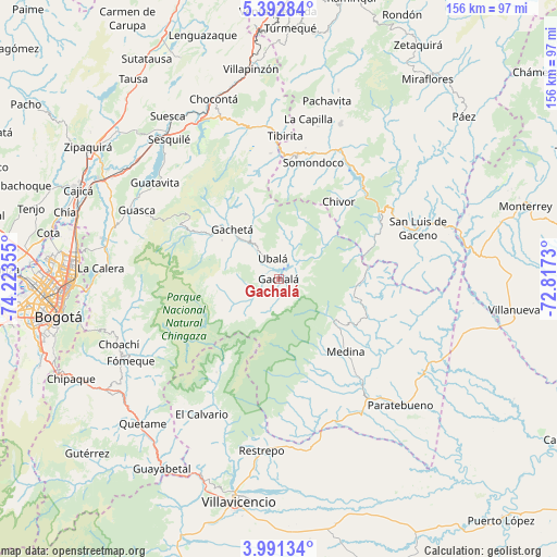
Gachalá GPS coordinates[2]
4° 41' 32.784" North, 73° 31' 13.512" West
| Map corner | latitude | longitude |
|---|---|---|
| Upper-left | 5.39284°, | -74.22355° |
| Center: | 4.69244°, | -73.52042° |
| Lower-right: | 3.99134°, | -72.8173° |
| Map W x H: | 155.8×155.8 km | = 96.8×96.8mi |
| max Lat: | 13.38166° ⇑68.5% North |
| Gachalá: | 4.69244° |
| min Lat: | ⇓31.5% South -4.21528° |
| min Long | Gachalá | max Long |
| -81.70636° | -73.52042° | -67.06996° |
| W 75%⇐ | ⇒25% E |
Elevation
Elevation of Gachalá is 1729 m = 5673 ft, and this is 579.7 m = 1902 ft above average elevation for this country.
| Max E: |
3342 m = 10965 ft | 30% |
| Gachalá | 1729 m 5673 ft | |
| Avg. | 1149.3 m = 3771 ft | |
Min E: |
1 m = 3 ft | 70% |
See also: Colombia elevation on elevation.city.
Geographical zone
Gachalá is located in North Torrid zone (between Equator and Tropic of Cancer). Distance of Equator is 521.8 km =324.2 mi to South.| Distance of | km | miles | from Gachalá |
|---|---|---|---|
| North Pole | 9485.3 | 5893.9 | to North |
| Arctic Circle | 6879.4 | 4274.7 | to North |
| Tropic Cancer | 2084.2 | 1295.1 | to North |
| Equator | 521.8 | 324.2 | to South |


Nearby cities:
15 places around Gachalá: (largest is in red/bold)
• Almeida
34.7 km =21.6 mi,  26°
26°
• Chivor
27.3 km =17 mi,  38°
38°
• Gachetá
19 km =11.8 mi,  317°
317°
• Gama
12.7 km =7.9 mi,  307°
307°
• Guateque
35.3 km =21.9 mi,  8°
8°
• Guayatá
30.4 km =18.9 mi, 6°
• Junín
18.9 km =11.7 mi, 305°
• Macanal
38.2 km =23.7 mi, 35°
• Manta
35.2 km =21.9 mi,  356°
356°
• Medina
27.7 km =17.2 mi,  137°
137°
• San Juanito
31.3 km =19.4 mi,  214°
214°
• Santa María
34.2 km =21.3 mi,  56°
56°
• Somondoco
34 km =21.1 mi,  16°
16°
• Sutatenza
37.5 km =23.3 mi, 11°
• Ubalá
5.9 km =3.7 mi,  344°
344°
Sources, notices
• [Note1] Compared only with cities in Colombia existing in our database
• [Src1] Map data: © OpenStreetMap contributors (CC-BY-SA)
• [Src2] Other city data from geonames.org with taken over terms of usage.
• [Src3] Geographical zone / Annual Mean Temperature by Robert A. Rohde @ Wikipedia
