Pacayas geodata
Pacayas (Cartago) is a populated place; located in Costa Rica in America/Costa_Rica (GMT-6) time zone. With population of 1,556 people, there are 110 cities with bigger population in this country. Compared to other cities in Costa Rica, 84.3% of cities are located further ↑North; 65.7% of cities are located further ←West and 97.8% of cities have lower elevation than Pacayas. Note1


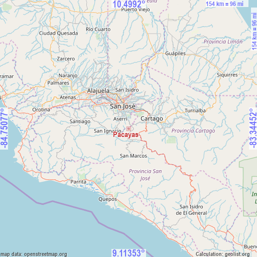
Pacayas GPS coordinates[2]
9° 48' 25.524" North, 84° 2' 51.504" West
| Map corner | latitude | longitude |
|---|---|---|
| Upper-left | 10.4992°, | -84.75077° |
| Center: | 9.80709°, | -84.04764° |
| Lower-right: | 9.11353°, | -83.34452° |
| Map W x H: | 154.1×154.1 km | = 95.8×95.8mi |
| max Lat: | 11.07377° ⇑84.3% North |
| Pacayas: | 9.80709° |
| min Lat: | ⇓15.7% South 8.53305° |
| min Long | Pacayas | max Long |
| -85.64748° | -84.04764° | -82.62185° |
| W 65.7%⇐ | ⇒34.3% E |
Elevation
Elevation of Pacayas is 1675 m = 5495 ft, and this is 940 m = 3084 ft above average elevation for this country.
| Max E: |
1844 m = 6050 ft | 2.2% |
| Pacayas | 1675 m 5495 ft | |
| Avg. | 735 m = 2411 ft | |
Min E: |
7 m = 23 ft | 97.8% |
See also: Costa Rica elevation on elevation.city.
Geographical zone
Pacayas is located in North Torrid zone (between Equator and Tropic of Cancer). Distance of Equator is 1090.4 km =677.5 mi to South.| Distance of | km | miles | from Pacayas |
|---|---|---|---|
| North Pole | 8916.6 | 5540.5 | to North |
| Arctic Circle | 6310.7 | 3921.3 | to North |
| Tropic Cancer | 1515.5 | 941.7 | to North |
| Equator | 1090.4 | 677.5 | to South |


Nearby cities:
15 places around Pacayas: (largest is in red/bold)
• Alajuelita
12 km =7.5 mi,  331°
331°
• Aserrí
7.5 km =4.7 mi,  319°
319°
• Curridabat
11.7 km =7.3 mi,  7°
7°
• Monterrey
8.8 km =5.5 mi,  230°
230°
• Patarrá
8.3 km =5.2 mi, 9°
• Salitrillos
6.9 km =4.3 mi, 317°
• San Diego
11.3 km =7 mi,  25°
25°
• San Felipe
12.6 km =7.8 mi, 329°
• San Ignacio
12.5 km =7.8 mi,  265°
265°
• San Juan de Dios
8.8 km =5.5 mi, 332°
• San Miguel
7.3 km =4.5 mi,  348°
348°
• San Pedro
13.5 km =8.4 mi,  358°
358°
• San Rafael Arriba
8.2 km =5.1 mi,  337°
337°
• Tobosi
7.8 km =4.8 mi,  63°
63°
• Tres Ríos
12.9 km =8 mi, 30°
Sources, notices
• [Note1] Compared only with cities in Costa Rica existing in our database
• [Src1] Map data: © OpenStreetMap contributors (CC-BY-SA)
• [Src2] Other city data from geonames.org with taken over terms of usage.
• [Src3] Geographical zone / Annual Mean Temperature by Robert A. Rohde @ Wikipedia
