San Juan de Dios geodata
San Juan de Dios (San José) is a populated place; located in Costa Rica in America/Costa_Rica (GMT-6) time zone. With population of 15,469 people, there are 38 cities with bigger population in this country. Compared to other cities in Costa Rica, 72.4% of cities are located further ↑North; 58.2% of cities are located further ←West and 78.4% of cities have lower elevation than San Juan de Dios. Note1


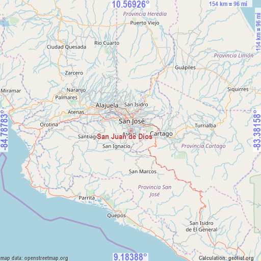
San Juan de Dios GPS coordinates[2]
9° 52' 38.28" North, 84° 5' 4.92" West
| Map corner | latitude | longitude |
|---|---|---|
| Upper-left | 10.56926°, | -84.78783° |
| Center: | 9.8773°, | -84.0847° |
| Lower-right: | 9.18388°, | -83.38158° |
| Map W x H: | 154×154 km | = 95.7×95.7mi |
| max Lat: | 11.07377° ⇑72.4% North |
| San Juan de Dios: | 9.8773° |
| min Lat: | ⇓27.6% South 8.53305° |
| min Long | San Juan de Dio | max Long |
| -85.64748° | -84.0847° | -82.62185° |
| W 58.2%⇐ | ⇒41.8% E |
Elevation
Elevation of San Juan de Dios is 1207 m = 3960 ft, and this is 472 m = 1549 ft above average elevation for this country.
| Max E: |
1844 m = 6050 ft | 21.6% |
| San Juan de Dios | 1207 m 3960 ft | |
| Avg. | 735 m = 2411 ft | |
Min E: |
7 m = 23 ft | 78.4% |
See also: Costa Rica elevation on elevation.city.
Geographical zone
San Juan de Dios is located in North Torrid zone (between Equator and Tropic of Cancer). Distance of Equator is 1098.3 km =682.5 mi to South.| Distance of | km | miles | from San Juan de Dios |
|---|---|---|---|
| North Pole | 8908.8 | 5535.7 | to North |
| Arctic Circle | 6302.9 | 3916.4 | to North |
| Tropic Cancer | 1507.7 | 936.8 | to North |
| Equator | 1098.3 | 682.5 | to South |


Nearby cities:
15 places around San Juan de Dios: (largest is in red/bold)
• Alajuelita
3.2 km =2 mi,  327°
327°
• Aserrí
2.2 km =1.4 mi,  201°
201°
• Calle Blancos
8.3 km =5.2 mi,  13°
13°
• Colima
8.2 km =5.1 mi,  359°
359°
• Curridabat
6.7 km =4.2 mi,  55°
55°
• Escazú
7.6 km =4.7 mi,  307°
307°
• Guadalupe
8.4 km =5.2 mi,  21°
21°
• Patarrá
5.5 km =3.4 mi,  86°
86°
• Salitrillos
2.8 km =1.7 mi,  193°
193°
• San Felipe
3.8 km =2.4 mi,  323°
323°
• San José
6.2 km =3.9 mi,  1°
1°
• San Miguel
2.7 km =1.7 mi,  104°
104°
• San Pedro
6.8 km =4.2 mi,  33°
33°
• San Rafael
8 km =5 mi, 314°
• San Rafael Arriba
0.9 km =0.6 mi, 102°
Sources, notices
• [Note1] Compared only with cities in Costa Rica existing in our database
• [Src1] Map data: © OpenStreetMap contributors (CC-BY-SA)
• [Src2] Other city data from geonames.org with taken over terms of usage.
• [Src3] Geographical zone / Annual Mean Temperature by Robert A. Rohde @ Wikipedia
