Santa Cruz del Norte geodata
Santa Cruz del Norte (Mayabeque) is a seat of a second-order administrative division; located in Cuba in America/Havana (GMT-4) time zone. With population of 18,402 people, there are 114 cities with bigger population in this country. Compared to other cities in Cuba, 98.3% of cities are located further ↓South; 72.4% of cities are located further →East and 93.9% of cities have higher elevation than Santa Cruz del Norte. Note1


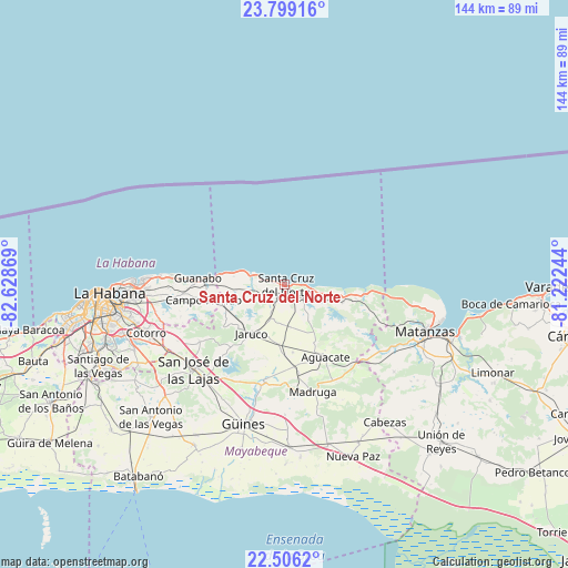
Santa Cruz del Norte GPS coordinates[2]
23° 9' 15.264" North, 81° 55' 32.016" West
| Map corner | latitude | longitude |
|---|---|---|
| Upper-left | 23.79916°, | -82.62869° |
| Center: | 23.15424°, | -81.92556° |
| Lower-right: | 22.5062°, | -81.22244° |
| Map W x H: | 143.8×143.8 km | = 89.4×89.4mi |
| max Lat: | 23.15917° ⇑1.7% North |
| Santa Cruz del Norte: | 23.15424° |
| min Lat: | ⇓98.3% South 19.90553° |
| min Long | Santa Cruz del | max Long |
| -84.28599° | -81.92556° | -74.15181° |
| W 27.6%⇐ | ⇒72.4% E |
Elevation
Elevation of Santa Cruz del Norte is 11 m = 36 ft, and this is 57.6 m = 189 ft below average elevation for this country.
| Max E: |
761 m = 2497 ft | 93.9% |
| Avg. | 68.6 m = 225 ft | |
| Santa Cruz del Norte | 11 m = 36 ft | |
Min E: |
3 m = 10 ft | 6.1% |
See also: Cuba elevation on elevation.city.
Geographical zone
Santa Cruz del Norte is located in North Torrid zone (between Equator and Tropic of Cancer). Distance of this Northern Tropic circle is 31.4 km =19.5 mi to North.| Distance of | km | miles | from Santa Cruz del Norte |
|---|---|---|---|
| North Pole | 7432.6 | 4618.4 | to North |
| Arctic Circle | 4826.7 | 2999.2 | to North |
| Tropic Cancer | 31.4 | 19.5 | to North |
| Equator | 2574.5 | 1599.7 | to South |


Nearby cities:
15 places around Santa Cruz del Norte: (largest is in red/bold)
• Alamar
36.1 km =22.4 mi,  270°
270°
• Centro Habana
44.9 km =27.9 mi, 267°
• Guanabacoa
38.5 km =23.9 mi,  264°
264°
• Güines
36.7 km =22.8 mi,  196°
196°
• Habana del Este
41.4 km =25.7 mi, 270°
• Jamaica
31.8 km =19.8 mi,  231°
231°
• Jaruco
14.9 km =9.3 mi,  214°
214°
• La Habana Vieja
43.8 km =27.2 mi, 266°
• Madruga
28.1 km =17.5 mi,  165°
165°
• Matanzas
37.8 km =23.5 mi,  109°
109°
• Mañalich
44.4 km =27.6 mi, 210°
• Regla
41.7 km =25.9 mi, 265°
• San José de las Lajas
31.5 km =19.6 mi, 227°
• San Miguel del Padrón
39 km =24.2 mi, 255°
• San Nicolás de Bari
41.1 km =25.5 mi,  178°
178°
Sources, notices
• [Note1] Compared only with cities in Cuba existing in our database
• [Src1] Map data: © OpenStreetMap contributors (CC-BY-SA)
• [Src2] Other city data from geonames.org with taken over terms of usage.
• [Src3] Geographical zone / Annual Mean Temperature by Robert A. Rohde @ Wikipedia
