Madruga geodata
Madruga (Mayabeque) is a seat of a second-order administrative division; located in Cuba in America/Havana (GMT-4) time zone. With population of 33,798 people, there are 73 cities with bigger population in this country. Compared to other cities in Cuba, 83.4% of cities are located further ↓South; 71.3% of cities are located further →East and 94.5% of cities have lower elevation than Madruga. Note1


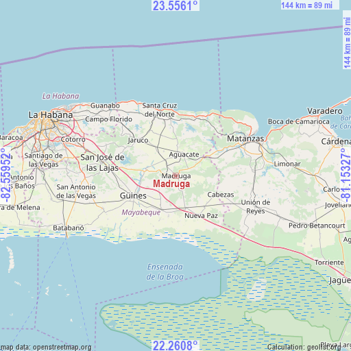
Madruga GPS coordinates[2]
22° 54' 36" North, 81° 51' 23.004" West
| Map corner | latitude | longitude |
|---|---|---|
| Upper-left | 23.5561°, | -82.55952° |
| Center: | 22.91°, | -81.85639° |
| Lower-right: | 22.2608°, | -81.15327° |
| Map W x H: | 144×144 km | = 89.5×89.5mi |
| max Lat: | 23.15917° ⇑16.6% North |
| Madruga: | 22.91° |
| min Lat: | ⇓83.4% South 19.90553° |
| min Long | Madruga | max Long |
| -84.28599° | -81.85639° | -74.15181° |
| W 28.7%⇐ | ⇒71.3% E |
Elevation
Elevation of Madruga is 150 m = 492 ft, and this is 81.4 m = 267 ft above average elevation for this country.
| Max E: |
761 m = 2497 ft | 5.5% |
| Madruga | 150 m 492 ft | |
| Avg. | 68.6 m = 225 ft | |
Min E: |
3 m = 10 ft | 94.5% |
See also: Cuba elevation on elevation.city.
Geographical zone
Madruga is located in North Torrid zone (between Equator and Tropic of Cancer). Distance of this Northern Tropic circle is 58.6 km =36.4 mi to North.| Distance of | km | miles | from Madruga |
|---|---|---|---|
| North Pole | 7459.7 | 4635.2 | to North |
| Arctic Circle | 4853.8 | 3016 | to North |
| Tropic Cancer | 58.6 | 36.4 | to North |
| Equator | 2547.4 | 1582.9 | to South |


Nearby cities:
15 places around Madruga: (largest is in red/bold)
• Alacranes
33.5 km =20.8 mi,  118°
118°
• Bolondrón
44.9 km =27.9 mi,  111°
111°
• Guara
37.2 km =23.1 mi,  252°
252°
• Güines
19.2 km =11.9 mi, 245°
• Jamaica
32.8 km =20.4 mi,  282°
282°
• Jaruco
21.6 km =13.4 mi,  313°
313°
• Limonar
45.9 km =28.5 mi,  84°
84°
• Matanzas
32.1 km =19.9 mi,  62°
62°
• Mañalich
31.8 km =19.8 mi, 249°
• Melena del Sur
33.1 km =20.6 mi, 245°
• Nueva Paz
19.3 km =12 mi,  147°
147°
• San José de las Lajas
30.7 km =19.1 mi, 280°
• San Nicolás de Bari
15.1 km =9.4 mi,  202°
202°
• Santa Cruz del Norte
28.1 km =17.5 mi,  345°
345°
• Unión de Reyes
35.2 km =21.9 mi, 111°
Sources, notices
• [Note1] Compared only with cities in Cuba existing in our database
• [Src1] Map data: © OpenStreetMap contributors (CC-BY-SA)
• [Src2] Other city data from geonames.org with taken over terms of usage.
• [Src3] Geographical zone / Annual Mean Temperature by Robert A. Rohde @ Wikipedia
