Najasa geodata
Najasa (Camagüey) is a seat of a second-order administrative division; located in Cuba in America/Havana (GMT-4) time zone. In our database, there are 154 cities with bigger population. Compared to other cities in Cuba, 74% of cities are located further ↑North; 70.7% of cities are located further ←West and 85.6% of cities have lower elevation than Najasa. Note1


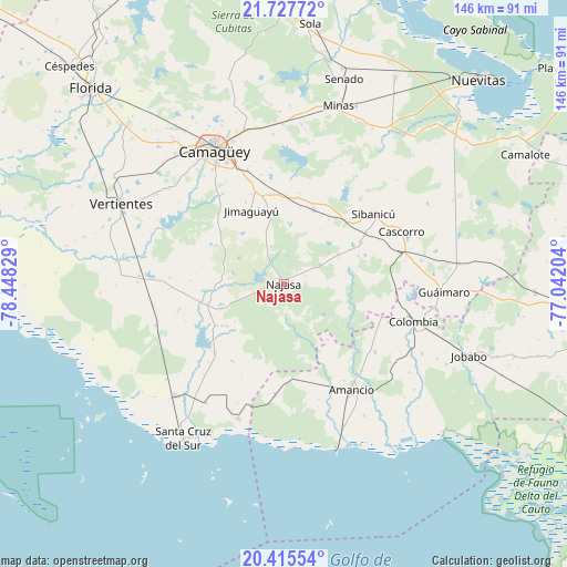
Najasa GPS coordinates[2]
21° 4' 23.088" North, 77° 44' 42.576" West
| Map corner | latitude | longitude |
|---|---|---|
| Upper-left | 21.72772°, | -78.44829° |
| Center: | 21.07308°, | -77.74516° |
| Lower-right: | 20.41554°, | -77.04204° |
| Map W x H: | 145.9×145.9 km | = 90.7×90.7mi |
| max Lat: | 23.15917° ⇑74% North |
| Najasa: | 21.07308° |
| min Lat: | ⇓26% South 19.90553° |
| min Long | Najasa | max Long |
| -84.28599° | -77.74516° | -74.15181° |
| W 70.7%⇐ | ⇒29.3% E |
Elevation
Elevation of Najasa is 113 m = 371 ft, and this is 44.4 m = 146 ft above average elevation for this country.
| Max E: |
761 m = 2497 ft | 14.4% |
| Najasa | 113 m 371 ft | |
| Avg. | 68.6 m = 225 ft | |
Min E: |
3 m = 10 ft | 85.6% |
See also: Cuba elevation on elevation.city.
Geographical zone
Najasa is located in North Torrid zone (between Equator and Tropic of Cancer). Distance of this Northern Tropic circle is 262.8 km =163.3 mi to North.| Distance of | km | miles | from Najasa |
|---|---|---|---|
| North Pole | 7664 | 4762.2 | to North |
| Arctic Circle | 5058.1 | 3143 | to North |
| Tropic Cancer | 262.8 | 163.3 | to North |
| Equator | 2343.1 | 1455.9 | to South |


Nearby cities:
15 places around Najasa: (largest is in red/bold)
• Amancio
33.1 km =20.6 mi,  148°
148°
• Camagüey
38.6 km =24 mi,  332°
332°
• Carlos Manuel de Céspedes
78.9 km =49 mi,  315°
315°
• Colombia
34.4 km =21.4 mi,  105°
105°
• Cubitas
71.1 km =44.2 mi,  358°
358°
• El Caney
80.6 km =50.1 mi,  288°
288°
• Florida
70.8 km =44 mi, 315°
• Guáimaro
41.1 km =25.5 mi,  93°
93°
• Jimaguayú
20.6 km =12.8 mi,  335°
335°
• Jobabo
51.5 km =32 mi, 110°
• Minas
48.2 km =30 mi,  16°
16°
• Nuevitas
72.4 km =45 mi,  43°
43°
• Santa Cruz del Sur
47.6 km =29.6 mi,  213°
213°
• Sibanicú
29.1 km =18.1 mi,  51°
51°
• Vertientes
46.7 km =29 mi,  296°
296°
Sources, notices
• [Note1] Compared only with cities in Cuba existing in our database
• [Src1] Map data: © OpenStreetMap contributors (CC-BY-SA)
• [Src2] Other city data from geonames.org with taken over terms of usage.
• [Src3] Geographical zone / Annual Mean Temperature by Robert A. Rohde @ Wikipedia
