El Caney geodata
El Caney (Camagüey) is a populated locality; located in Cuba in America/Havana (GMT-4) time zone. With population of 4,597 people, there are 148 cities with bigger population in this country. Compared to other cities in Cuba, 70.2% of cities are located further ↑North; 64.6% of cities are located further ←West and 100% of cities have higher elevation than El Caney. Note1


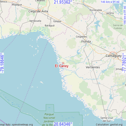
El Caney GPS coordinates[2]
21° 18' 0" North, 78° 28' 59.988" West
| Map corner | latitude | longitude |
|---|---|---|
| Upper-left | 21.95362°, | -79.18646° |
| Center: | 21.3°, | -78.48333° |
| Lower-right: | 20.64346°, | -77.78021° |
| Map W x H: | 145.7×145.7 km | = 90.5×90.5mi |
| max Lat: | 23.15917° ⇑70.2% North |
| El Caney: | 21.3° |
| min Lat: | ⇓29.8% South 19.90553° |
| min Long | El Caney | max Long |
| -84.28599° | -78.48333° | -74.15181° |
| W 64.6%⇐ | ⇒35.4% E |
Elevation
Elevation of El Caney is 3 m = 10 ft, and this is 65.6 m = 215 ft below average elevation for this country.
| Max E: |
761 m = 2497 ft | 100% |
| Avg. | 68.6 m = 225 ft | |
| El Caney | 3 m = 10 ft | |
Min E: |
3 m = 10 ft | 0% |
See also: Cuba elevation on elevation.city.
Geographical zone
El Caney is located in North Torrid zone (between Equator and Tropic of Cancer). Distance of this Northern Tropic circle is 237.6 km =147.6 mi to North.| Distance of | km | miles | from El Caney |
|---|---|---|---|
| North Pole | 7638.7 | 4746.5 | to North |
| Arctic Circle | 5032.8 | 3127.2 | to North |
| Tropic Cancer | 237.6 | 147.6 | to North |
| Equator | 2368.3 | 1471.6 | to South |


Nearby cities:
15 places around El Caney: (largest is in red/bold)
• Baraguá
45 km =28 mi,  340°
340°
• Camagüey
59.3 km =36.8 mi,  81°
81°
• Carlos Manuel de Céspedes
37 km =23 mi,  34°
34°
• Ciego de Ávila
66.6 km =41.4 mi,  334°
334°
• Ciro Redondo
83.1 km =51.6 mi, 344°
• Esmeralda
72.1 km =44.8 mi, 31°
• Florida
36.6 km =22.7 mi,  46°
46°
• Gaspar
49.2 km =30.6 mi,  352°
352°
• Jimaguayú
68.4 km =42.5 mi,  95°
95°
• Majagua
87.2 km =54.2 mi,  321°
321°
• Najasa
80.6 km =50.1 mi,  108°
108°
• Primero de Enero
71.9 km =44.7 mi,  4°
4°
• Santa Cruz del Sur
82.1 km =51 mi,  142°
142°
• Venezuela
58.3 km =36.2 mi, 326°
• Vertientes
34.9 km =21.7 mi, 97°
Sources, notices
• [Note1] Compared only with cities in Cuba existing in our database
• [Src1] Map data: © OpenStreetMap contributors (CC-BY-SA)
• [Src2] Other city data from geonames.org with taken over terms of usage.
• [Src3] Geographical zone / Annual Mean Temperature by Robert A. Rohde @ Wikipedia
