Camagüey geodata
Camagüey is a seat of a first-order administrative division; located in Cuba in America/Havana (GMT-4) time zone. With population of 347,562 people, there are 2 cities with bigger population in this country. Compared to other cities in Cuba, 69.1% of cities are located further ↑North; 69.1% of cities are located further ←West and 81.8% of cities have lower elevation than Camagüey. Note1


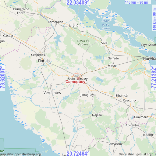
Camagüey GPS coordinates[2]
21° 22' 50.988" North, 77° 55' 0.984" West
| Map corner | latitude | longitude |
|---|---|---|
| Upper-left | 22.03409°, | -78.62007° |
| Center: | 21.38083°, | -77.91694° |
| Lower-right: | 20.72464°, | -77.21382° |
| Map W x H: | 145.6×145.6 km | = 90.5×90.5mi |
| max Lat: | 23.15917° ⇑69.1% North |
| Camagüey: | 21.38083° |
| min Lat: | ⇓30.9% South 19.90553° |
| min Long | Camagüey | max Long |
| -84.28599° | -77.91694° | -74.15181° |
| W 69.1%⇐ | ⇒30.9% E |
Elevation
Elevation of Camagüey is 102 m = 335 ft, and this is 33.4 m = 110 ft above average elevation for this country.
| Max E: |
761 m = 2497 ft | 18.2% |
| Camagüey | 102 m 335 ft | |
| Avg. | 68.6 m = 225 ft | |
Min E: |
3 m = 10 ft | 81.8% |
See also: Camagüey elevation on elevation.city.
Geographical zone
Camagüey is located in North Torrid zone (between Equator and Tropic of Cancer). Distance of this Northern Tropic circle is 228.6 km =142 mi to North.| Distance of | km | miles | from Camagüey |
|---|---|---|---|
| North Pole | 7629.7 | 4740.9 | to North |
| Arctic Circle | 5023.8 | 3121.6 | to North |
| Tropic Cancer | 228.6 | 142 | to North |
| Equator | 2377.3 | 1477.2 | to South |


Nearby cities:
15 places around Camagüey: (largest is in red/bold)
• Amancio
71.6 km =44.5 mi,  150°
150°
• Carlos Manuel de Céspedes
43.6 km =27.1 mi,  299°
299°
• Colombia
67.1 km =41.7 mi,  130°
130°
• Cubitas
40.2 km =25 mi,  23°
23°
• El Caney
59.3 km =36.8 mi,  261°
261°
• Esmeralda
56.3 km =35 mi,  338°
338°
• Florida
35.8 km =22.2 mi, 296°
• Guáimaro
69.2 km =43 mi,  121°
121°
• Jimaguayú
18 km =11.2 mi, 148°
• Minas
33.9 km =21.1 mi,  69°
69°
• Najasa
38.6 km =24 mi, 152°
• Nuevitas
69.9 km =43.4 mi, 74°
• Santa Cruz del Sur
74.4 km =46.2 mi,  186°
186°
• Sibanicú
43.6 km =27.1 mi,  111°
111°
• Vertientes
27.7 km =17.2 mi,  240°
240°
Sources, notices
• [Note1] Compared only with cities in Cuba existing in our database
• [Src1] Map data: © OpenStreetMap contributors (CC-BY-SA)
• [Src2] Other city data from geonames.org with taken over terms of usage.
• [Src3] Geographical zone / Annual Mean Temperature by Robert A. Rohde @ Wikipedia
