Colombia geodata
Colombia (Las Tunas) is a seat of a second-order administrative division; located in Cuba in America/Havana (GMT-4) time zone. With population of 20,096 people, there are 105 cities with bigger population in this country. Compared to other cities in Cuba, 75.7% of cities are located further ↑North; 74% of cities are located further ←West and 61.9% of cities have lower elevation than Colombia. Note1


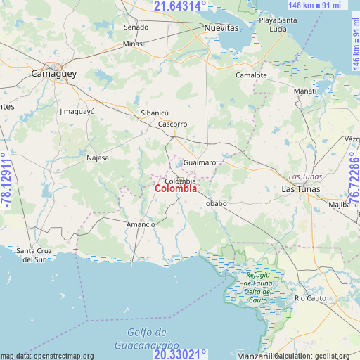
Colombia GPS coordinates[2]
20° 59' 17.232" North, 77° 25' 33.528" West
| Map corner | latitude | longitude |
|---|---|---|
| Upper-left | 21.64314°, | -78.12911° |
| Center: | 20.98812°, | -77.42598° |
| Lower-right: | 20.33021°, | -76.72286° |
| Map W x H: | 146×146 km | = 90.7×90.7mi |
| max Lat: | 23.15917° ⇑75.7% North |
| Colombia: | 20.98812° |
| min Lat: | ⇓24.3% South 19.90553° |
| min Long | Colombia | max Long |
| -84.28599° | -77.42598° | -74.15181° |
| W 74%⇐ | ⇒26% E |
Elevation
Elevation of Colombia is 64 m = 210 ft, and this is 4.6 m = 15 ft below average elevation for this country.
| Max E: |
761 m = 2497 ft | 38.1% |
| Avg. | 68.6 m = 225 ft | |
| Colombia | 64 m = 210 ft | |
Min E: |
3 m = 10 ft | 61.9% |
See also: Cuba elevation on elevation.city.
Geographical zone
Colombia is located in North Torrid zone (between Equator and Tropic of Cancer). Distance of this Northern Tropic circle is 272.3 km =169.2 mi to North.| Distance of | km | miles | from Colombia |
|---|---|---|---|
| North Pole | 7673.4 | 4768 | to North |
| Arctic Circle | 5067.5 | 3148.8 | to North |
| Tropic Cancer | 272.3 | 169.2 | to North |
| Equator | 2333.7 | 1450.1 | to South |


Nearby cities:
15 places around Colombia: (largest is in red/bold)
• Amancio
24.6 km =15.3 mi,  220°
220°
• Calixto
58.1 km =36.1 mi,  97°
97°
• Camagüey
67.1 km =41.7 mi,  310°
310°
• Guáimaro
10.6 km =6.6 mi,  47°
47°
• Jimaguayú
50.2 km =31.2 mi,  304°
304°
• Jobabo
17.4 km =10.8 mi,  120°
120°
• Las Tunas
49.4 km =30.7 mi,  93°
93°
• Manatí
62.4 km =38.8 mi, 54°
• Manzanillo
78.6 km =48.8 mi,  156°
156°
• Minas
58.8 km =36.5 mi,  341°
341°
• Najasa
34.4 km =21.4 mi,  285°
285°
• Nuevitas
64.2 km =39.9 mi,  15°
15°
• Río Cauto
71.2 km =44.2 mi,  131°
131°
• Santa Cruz del Sur
66.7 km =41.4 mi,  243°
243°
• Sibanicú
29.5 km =18.3 mi, 339°
Sources, notices
• [Note1] Compared only with cities in Cuba existing in our database
• [Src1] Map data: © OpenStreetMap contributors (CC-BY-SA)
• [Src2] Other city data from geonames.org with taken over terms of usage.
• [Src3] Geographical zone / Annual Mean Temperature by Robert A. Rohde @ Wikipedia
