Zýgi geodata
Zýgi (Larnaka) is a populated place; located in Cyprus in Asia/Nicosia (GMT+3) time zone. With population of 526 people, there are 112 cities with bigger population in this country. Compared to other cities in Cyprus, 90.6% of cities are located further ↑North; 63.2% of cities are located further ←West and 96.6% of cities have higher elevation than Zýgi. Note1


Zýgi GPS coordinates[2]
34° 43' 52.86" North, 33° 20' 14.712" East
| Map corner | latitude | longitude |
|---|---|---|
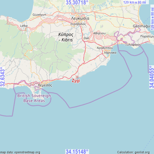
| Upper-left | 35.30718°, | 32.6343° |
| Center: | 34.73135°, | 33.33742° |
| Lower-right: | 34.15148°, | 34.04055° |
| Map W x H: | 128.5×128.5 km | = 79.8×79.8mi |
| max Lat: | 35.59719° ⇑90.6% North |
| Zýgi: | 34.73135° |
| min Lat: | ⇓9.4% South 34.66865° |
| min Long | Zýgi | max Long |
| 32.38166° | 33.33742° | 34.37916° |
| W 63.2%⇐ | ⇒36.8% E |
Elevation
Elevation of Zýgi is 13 m = 43 ft, and this is 195 m = 640 ft below average elevation for this country.
| Max E: |
1134 m = 3720 ft | 96.6% |
| Avg. | 208 m = 682 ft | |
| Zýgi | 13 m = 43 ft | |
Min E: |
4 m = 13 ft | 3.4% |
See also: Cyprus elevation on elevation.city.
Geographical zone
Zýgi is located in North temperate zone (between Tropic of Cancer and the Arctic Circle). Distance of this Northern Tropic circle is 1255.8 km =780.3 mi to South.| Distance of | km | miles | from Zýgi |
|---|---|---|---|
| North Pole | 6145.3 | 3818.5 | to North |
| Arctic Circle | 3539.4 | 2199.3 | to North |
| Tropic Cancer | 1255.8 | 780.3 | to South |
| Equator | 3861.8 | 2399.6 | to South |


Nearby cities:
15 places around Zýgi: (largest is in red/bold)
• Alethrikó
20.3 km =12.6 mi,  45°
45°
• Anafotída
15.5 km =9.6 mi, 47°
• Choirokoitía
7.4 km =4.6 mi,  357°
357°
• Kalavasos
6 km =3.7 mi,  320°
320°
• Kofínou
11.5 km =7.1 mi,  25°
25°
• Kórnos
22.1 km =13.7 mi,  14°
14°
• Lythrodóntas
24.7 km =15.3 mi,  351°
351°
• Maróni
3.4 km =2.1 mi, 31°
• Mazotós
16 km =9.9 mi,  59°
59°
• Mouttagiáka
21.7 km =13.5 mi,  266°
266°
• Parekklisha
16.4 km =10.2 mi,  275°
275°
• Pyrgos
14.1 km =8.8 mi, 274°
• Páno Léfkara
15.2 km =9.4 mi, 349°
• Tersefánou
23.5 km =14.6 mi, 54°
• Ágios Týchon
18.2 km =11.3 mi, 268°
Sources, notices
• [Note1] Compared only with cities in Cyprus existing in our database
• [Src1] Map data: © OpenStreetMap contributors (CC-BY-SA)
• [Src2] Other city data from geonames.org with taken over terms of usage.
• [Src3] Geographical zone / Annual Mean Temperature by Robert A. Rohde @ Wikipedia
