Mazotós geodata
Mazotós (Larnaka) is a populated place; located in Cyprus in Asia/Nicosia (GMT+3) time zone. With population of 818 people, there are 93 cities with bigger population in this country. Compared to other cities in Cyprus, 76.1% of cities are located further ↑North; 74.4% of cities are located further ←West and 83.8% of cities have higher elevation than Mazotós. Note1


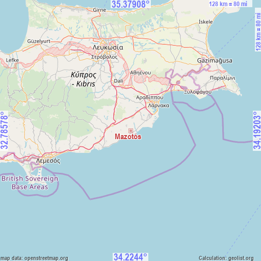
Mazotós GPS coordinates[2]
34° 48' 13.536" North, 33° 29' 20.04" East
| Map corner | latitude | longitude |
|---|---|---|
| Upper-left | 35.37908°, | 32.78578° |
| Center: | 34.80376°, | 33.4889° |
| Lower-right: | 34.2244°, | 34.19203° |
| Map W x H: | 128.4×128.4 km | = 79.8×79.8mi |
| max Lat: | 35.59719° ⇑76.1% North |
| Mazotós: | 34.80376° |
| min Lat: | ⇓23.9% South 34.66865° |
| min Long | Mazotós | max Long |
| 32.38166° | 33.4889° | 34.37916° |
| W 74.4%⇐ | ⇒25.6% E |
Elevation
Elevation of Mazotós is 34 m = 112 ft, and this is 174 m = 571 ft below average elevation for this country.
| Max E: |
1134 m = 3720 ft | 83.8% |
| Avg. | 208 m = 682 ft | |
| Mazotós | 34 m = 112 ft | |
Min E: |
4 m = 13 ft | 16.2% |
See also: Cyprus elevation on elevation.city.
Geographical zone
Mazotós is located in North temperate zone (between Tropic of Cancer and the Arctic Circle). Distance of this Northern Tropic circle is 1263.9 km =785.4 mi to South.| Distance of | km | miles | from Mazotós |
|---|---|---|---|
| North Pole | 6137.2 | 3813.5 | to North |
| Arctic Circle | 3531.4 | 2194.3 | to North |
| Tropic Cancer | 1263.9 | 785.4 | to South |
| Equator | 3869.8 | 2404.6 | to South |


Nearby cities:
15 places around Mazotós: (largest is in red/bold)
• Alethrikó
6.3 km =3.9 mi,  4°
4°
• Anafotída
3.3 km =2.1 mi,  314°
314°
• Choirokoitía
14.1 km =8.8 mi,  267°
267°
• Dhromolaxia
12 km =7.5 mi,  48°
48°
• Kalavasos
17.9 km =11.1 mi,  259°
259°
• Kofínou
9.2 km =5.7 mi,  284°
284°
• Kíti
9.1 km =5.7 mi,  58°
58°
• Kórnos
15.7 km =9.8 mi,  328°
328°
• Maróni
13.1 km =8.1 mi,  246°
246°
• Meneou
11.6 km =7.2 mi, 56°
• Mosfilotí
17.5 km =10.9 mi,  340°
340°
• Perivólia
9.1 km =5.7 mi,  68°
68°
• Psevdás
16.1 km =10 mi,  351°
351°
• Tersefánou
7.7 km =4.8 mi,  43°
43°
• Zýgi
16 km =9.9 mi,  239°
239°
Sources, notices
• [Note1] Compared only with cities in Cyprus existing in our database
• [Src1] Map data: © OpenStreetMap contributors (CC-BY-SA)
• [Src2] Other city data from geonames.org with taken over terms of usage.
• [Src3] Geographical zone / Annual Mean Temperature by Robert A. Rohde @ Wikipedia
