Anafotída geodata
Anafotída (Larnaka) is a populated place; located in Cyprus in Asia/Nicosia (GMT+2) time zone. With population of 683 people, there are 99 cities with bigger population in this country. Compared to other cities in Cyprus, 70.9% of cities are located further ↑North; 73.5% of cities are located further ←West and 57.3% of cities have higher elevation than Anafotída. Note1


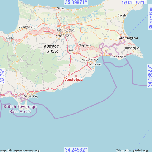
Anafotída GPS coordinates[2]
34° 49' 28.344" North, 33° 27' 47.232" East
| Map corner | latitude | longitude |
|---|---|---|
| Upper-left | 35.39971°, | 32.76° |
| Center: | 34.82454°, | 33.46312° |
| Lower-right: | 34.24532°, | 34.16625° |
| Map W x H: | 128.4×128.4 km | = 79.8×79.8mi |
| max Lat: | 35.59719° ⇑70.9% North |
| Anafotída: | 34.82454° |
| min Lat: | ⇓29.1% South 34.66865° |
| min Long | Anafotída | max Long |
| 32.38166° | 33.46312° | 34.37916° |
| W 73.5%⇐ | ⇒26.5% E |
Elevation
Elevation of Anafotída is 92 m = 302 ft, and this is 116 m = 381 ft below average elevation for this country.
| Max E: |
1134 m = 3720 ft | 57.3% |
| Avg. | 208 m = 682 ft | |
| Anafotída | 92 m = 302 ft | |
Min E: |
4 m = 13 ft | 42.7% |
See also: Cyprus elevation on elevation.city.
Geographical zone
Anafotída is located in North temperate zone (between Tropic of Cancer and the Arctic Circle). Distance of this Northern Tropic circle is 1266.2 km =786.8 mi to South.| Distance of | km | miles | from Anafotída |
|---|---|---|---|
| North Pole | 6134.9 | 3812 | to North |
| Arctic Circle | 3529 | 2192.8 | to North |
| Tropic Cancer | 1266.2 | 786.8 | to South |
| Equator | 3872.1 | 2406 | to South |


Nearby cities:
15 places around Anafotída: (largest is in red/bold)
• Alethrikó
4.9 km =3 mi,  35°
35°
• Choirokoitía
12.1 km =7.5 mi,  256°
256°
• Dhromolaxia
12.6 km =7.8 mi,  63°
63°
• Kofínou
6.6 km =4.1 mi,  269°
269°
• Kíti
10.4 km =6.5 mi,  76°
76°
• Kórnos
12.6 km =7.8 mi,  331°
331°
• Maróni
12.3 km =7.6 mi,  232°
232°
• Mazotós
3.3 km =2.1 mi,  134°
134°
• Meneou
12.7 km =7.9 mi,  71°
71°
• Mosfilotí
14.7 km =9.1 mi,  346°
346°
• Perivólia
10.9 km =6.8 mi, 84°
• Psevdás
13.6 km =8.5 mi,  359°
359°
• Páno Léfkara
15 km =9.3 mi,  288°
288°
• Tersefánou
8.4 km =5.2 mi, 66°
• Zýgi
15.5 km =9.6 mi, 227°
Sources, notices
• [Note1] Compared only with cities in Cyprus existing in our database
• [Src1] Map data: © OpenStreetMap contributors (CC-BY-SA)
• [Src2] Other city data from geonames.org with taken over terms of usage.
• [Src3] Geographical zone / Annual Mean Temperature by Robert A. Rohde @ Wikipedia
