Páno Léfkara geodata
Páno Léfkara (Larnaka) is a populated place; located in Cyprus in Asia/Nicosia (GMT+2) time zone. With population of 957 people, there are 85 cities with bigger population in this country. Compared to other cities in Cyprus, 63.2% of cities are located further ↑North; 59% of cities are located further ←West and 92.3% of cities have lower elevation than Páno Léfkara. Note1


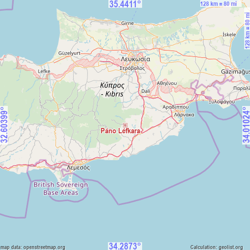
Páno Léfkara GPS coordinates[2]
34° 51' 58.392" North, 33° 18' 25.596" East
| Map corner | latitude | longitude |
|---|---|---|
| Upper-left | 35.4411°, | 32.60399° |
| Center: | 34.86622°, | 33.30711° |
| Lower-right: | 34.2873°, | 34.01024° |
| Map W x H: | 128.3×128.3 km | = 79.7×79.7mi |
| max Lat: | 35.59719° ⇑63.2% North |
| Páno Léfkara: | 34.86622° |
| min Lat: | ⇓36.8% South 34.66865° |
| min Long | Páno Léfkara | max Long |
| 32.38166° | 33.30711° | 34.37916° |
| W 59%⇐ | ⇒41% E |
Elevation
Elevation of Páno Léfkara is 583 m = 1913 ft, and this is 375 m = 1230 ft above average elevation for this country.
| Max E: |
1134 m = 3720 ft | 7.7% |
| Páno Léfkara | 583 m 1913 ft | |
| Avg. | 208 m = 682 ft | |
Min E: |
4 m = 13 ft | 92.3% |
See also: Cyprus elevation on elevation.city.
Geographical zone
Páno Léfkara is located in North temperate zone (between Tropic of Cancer and the Arctic Circle). Distance of this Northern Tropic circle is 1270.8 km =789.6 mi to South.| Distance of | km | miles | from Páno Léfkara |
|---|---|---|---|
| North Pole | 6130.3 | 3809.2 | to North |
| Arctic Circle | 3524.4 | 2190 | to North |
| Tropic Cancer | 1270.8 | 789.6 | to South |
| Equator | 3876.8 | 2408.9 | to South |


Nearby cities:
15 places around Páno Léfkara: (largest is in red/bold)
• Alethrikó
17.1 km =10.6 mi,  92°
92°
• Alámpra
16 km =9.9 mi,  31°
31°
• Anafotída
15 km =9.3 mi,  108°
108°
• Choirokoitía
8 km =5 mi,  161°
161°
• Kalavasos
10.4 km =6.5 mi,  185°
185°
• Kofínou
9 km =5.6 mi,  121°
121°
• Kórnos
10.5 km =6.5 mi,  52°
52°
• Lythrodóntas
9.5 km =5.9 mi,  354°
354°
• Maróni
12.9 km =8 mi, 159°
• Mathiátis
11.1 km =6.9 mi,  13°
13°
• Mosfilotí
14.4 km =8.9 mi, 48°
• Psevdás
16.8 km =10.4 mi,  57°
57°
• Pyrgos
17.9 km =11.1 mi,  219°
219°
• Siá
12.5 km =7.8 mi,  37°
37°
• Zýgi
15.2 km =9.4 mi,  169°
169°
Sources, notices
• [Note1] Compared only with cities in Cyprus existing in our database
• [Src1] Map data: © OpenStreetMap contributors (CC-BY-SA)
• [Src2] Other city data from geonames.org with taken over terms of usage.
• [Src3] Geographical zone / Annual Mean Temperature by Robert A. Rohde @ Wikipedia
