Choirokoitía geodata
Choirokoitía (Larnaka) is a populated place; located in Cyprus in Asia/Nicosia (GMT+3) time zone. With population of 531 people, there are 111 cities with bigger population in this country. Compared to other cities in Cyprus, 76.9% of cities are located further ↑North; 61.5% of cities are located further ←West and 64.1% of cities have lower elevation than Choirokoitía. Note1


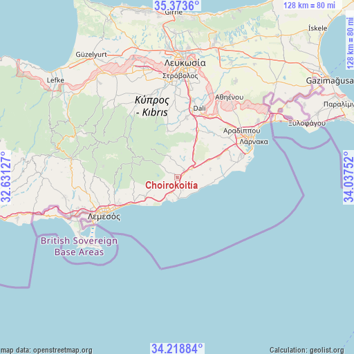
Choirokoitía GPS coordinates[2]
34° 47' 53.664" North, 33° 20' 3.804" East
| Map corner | latitude | longitude |
|---|---|---|
| Upper-left | 35.3736°, | 32.63127° |
| Center: | 34.79824°, | 33.33439° |
| Lower-right: | 34.21884°, | 34.03752° |
| Map W x H: | 128.4×128.4 km | = 79.8×79.8mi |
| max Lat: | 35.59719° ⇑76.9% North |
| Choirokoitía: | 34.79824° |
| min Lat: | ⇓23.1% South 34.66865° |
| min Long | Choirokoitía | max Long |
| 32.38166° | 33.33439° | 34.37916° |
| W 61.5%⇐ | ⇒38.5% E |
Elevation
Elevation of Choirokoitía is 227 m = 745 ft, and this is 19 m = 62 ft above average elevation for this country.
| Max E: |
1134 m = 3720 ft | 35.9% |
| Choirokoitía | 227 m 745 ft | |
| Avg. | 208 m = 682 ft | |
Min E: |
4 m = 13 ft | 64.1% |
See also: Cyprus elevation on elevation.city.
Geographical zone
Choirokoitía is located in North temperate zone (between Tropic of Cancer and the Arctic Circle). Distance of this Northern Tropic circle is 1263.3 km =785 mi to South.| Distance of | km | miles | from Choirokoitía |
|---|---|---|---|
| North Pole | 6137.9 | 3813.9 | to North |
| Arctic Circle | 3532 | 2194.7 | to North |
| Tropic Cancer | 1263.3 | 785 | to South |
| Equator | 3869.2 | 2404.2 | to South |


Nearby cities:
15 places around Choirokoitía: (largest is in red/bold)
• Alethrikó
16.2 km =10.1 mi,  64°
64°
• Anafotída
12.1 km =7.5 mi,  76°
76°
• Kalavasos
4.5 km =2.8 mi,  231°
231°
• Kofínou
6 km =3.7 mi, 60°
• Kórnos
15.1 km =9.4 mi,  22°
22°
• Lythrodóntas
17.3 km =10.7 mi,  348°
348°
• Maróni
5 km =3.1 mi,  155°
155°
• Mathiátis
18.4 km =11.4 mi,  0°
0°
• Mazotós
14.1 km =8.8 mi,  87°
87°
• Mosfilotí
19.1 km =11.9 mi,  25°
25°
• Parekklisha
17.1 km =10.6 mi,  250°
250°
• Pyrgos
15.2 km =9.4 mi, 245°
• Páno Léfkara
8 km =5 mi,  341°
341°
• Siá
18.2 km =11.3 mi, 16°
• Zýgi
7.4 km =4.6 mi,  177°
177°
Sources, notices
• [Note1] Compared only with cities in Cyprus existing in our database
• [Src1] Map data: © OpenStreetMap contributors (CC-BY-SA)
• [Src2] Other city data from geonames.org with taken over terms of usage.
• [Src3] Geographical zone / Annual Mean Temperature by Robert A. Rohde @ Wikipedia
