Kouklia geodata
Kouklia (Pafos) is a populated place; located in Cyprus in Asia/Nicosia (GMT+2) time zone. With population of 892 people, there are 87 cities with bigger population in this country. Compared to other cities in Cyprus, 94% of cities are located further ↑North; 81.2% of cities are located further →East and 84.6% of cities have higher elevation than Kouklia. Note1


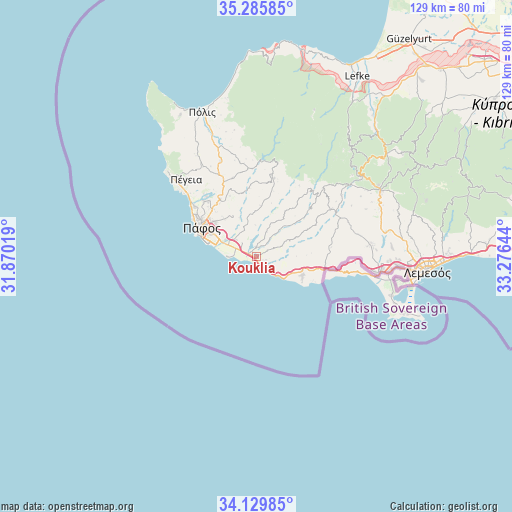
Kouklia GPS coordinates[2]
34° 42' 35.532" North, 32° 34' 23.916" East
| Map corner | latitude | longitude |
|---|---|---|
| Upper-left | 35.28585°, | 31.87019° |
| Center: | 34.70987°, | 32.57331° |
| Lower-right: | 34.12985°, | 33.27644° |
| Map W x H: | 128.5×128.5 km | = 79.8×79.8mi |
| max Lat: | 35.59719° ⇑94% North |
| Kouklia: | 34.70987° |
| min Lat: | ⇓6% South 34.66865° |
| min Long | Kouklia | max Long |
| 32.38166° | 32.57331° | 34.37916° |
| W 18.8%⇐ | ⇒81.2% E |
Elevation
Elevation of Kouklia is 33 m = 108 ft, and this is 175 m = 574 ft below average elevation for this country.
| Max E: |
1134 m = 3720 ft | 84.6% |
| Avg. | 208 m = 682 ft | |
| Kouklia | 33 m = 108 ft | |
Min E: |
4 m = 13 ft | 15.4% |
See also: Cyprus elevation on elevation.city.
Geographical zone
Kouklia is located in North temperate zone (between Tropic of Cancer and the Arctic Circle). Distance of this Northern Tropic circle is 1253.5 km =778.9 mi to South.| Distance of | km | miles | from Kouklia |
|---|---|---|---|
| North Pole | 6147.7 | 3820 | to North |
| Arctic Circle | 3541.8 | 2200.8 | to North |
| Tropic Cancer | 1253.5 | 778.9 | to South |
| Equator | 3859.4 | 2398.1 | to South |


Nearby cities:
15 places around Kouklia: (largest is in red/bold)
• Anaríta
5 km =3.1 mi,  313°
313°
• Avdímou
17.4 km =10.8 mi,  95°
95°
• Chlórakas
17.7 km =11 mi,  303°
303°
• Emba
17.4 km =10.8 mi, 308°
• Geroskipou
12.2 km =7.6 mi,  294°
294°
• Geroskípou (quarter)
12.6 km =7.8 mi, 297°
• Koloni
11 km =6.8 mi, 295°
• Konia
13.4 km =8.3 mi, 308°
• Lempa
18.7 km =11.6 mi, 306°
• Mesógi
16 km =9.9 mi,  317°
317°
• Paphos
15.5 km =9.6 mi, 298°
• Pissoúri
12.5 km =7.8 mi,  111°
111°
• Tsada - Tremithousa - Tala (Borders)
17.6 km =10.9 mi, 321°
• Tsáda
16.8 km =10.4 mi,  327°
327°
• Tími
5.8 km =3.6 mi, 296°
Sources, notices
• [Note1] Compared only with cities in Cyprus existing in our database
• [Src1] Map data: © OpenStreetMap contributors (CC-BY-SA)
• [Src2] Other city data from geonames.org with taken over terms of usage.
• [Src3] Geographical zone / Annual Mean Temperature by Robert A. Rohde @ Wikipedia
