Páno Panagía geodata
Páno Panagía (Pafos) is a populated place; located in Cyprus in Asia/Nicosia (GMT+2) time zone. With population of 564 people, there are 106 cities with bigger population in this country. Compared to other cities in Cyprus, 57.3% of cities are located further ↑North; 80.3% of cities are located further →East and 97.4% of cities have lower elevation than Páno Panagía. Note1


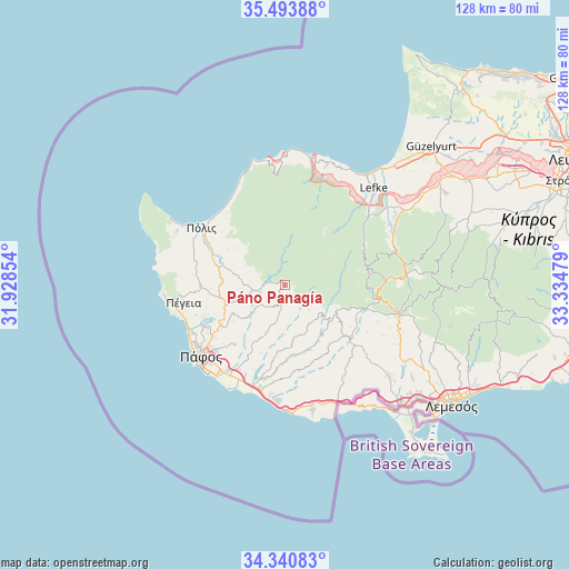
Páno Panagía GPS coordinates[2]
34° 55' 9.768" North, 32° 37' 53.976" East
| Map corner | latitude | longitude |
|---|---|---|
| Upper-left | 35.49388°, | 31.92854° |
| Center: | 34.91938°, | 32.63166° |
| Lower-right: | 34.34083°, | 33.33479° |
| Map W x H: | 128.2×128.2 km | = 79.7×79.7mi |
| max Lat: | 35.59719° ⇑57.3% North |
| Páno Panagía: | 34.91938° |
| min Lat: | ⇓42.7% South 34.66865° |
| min Long | Páno Panagía | max Long |
| 32.38166° | 32.63166° | 34.37916° |
| W 19.7%⇐ | ⇒80.3% E |
Elevation
Elevation of Páno Panagía is 848 m = 2782 ft, and this is 640 m = 2100 ft above average elevation for this country.
| Max E: |
1134 m = 3720 ft | 2.6% |
| Páno Panagía | 848 m 2782 ft | |
| Avg. | 208 m = 682 ft | |
Min E: |
4 m = 13 ft | 97.4% |
See also: Cyprus elevation on elevation.city.
Geographical zone
Páno Panagía is located in North temperate zone (between Tropic of Cancer and the Arctic Circle). Distance of this Northern Tropic circle is 1276.8 km =793.4 mi to South.| Distance of | km | miles | from Páno Panagía |
|---|---|---|---|
| North Pole | 6124.4 | 3805.5 | to North |
| Arctic Circle | 3518.5 | 2186.3 | to North |
| Tropic Cancer | 1276.8 | 793.4 | to South |
| Equator | 3882.7 | 2412.6 | to South |


Nearby cities:
15 places around Páno Panagía: (largest is in red/bold)
• Anaríta
21.8 km =13.5 mi,  204°
204°
• Argáka
20.6 km =12.8 mi,  322°
322°
• Emba
22.7 km =14.1 mi,  236°
236°
• Giólou
14.3 km =8.9 mi,  272°
272°
• Konia
21.7 km =13.5 mi,  226°
226°
• Mesógi
19.8 km =12.3 mi, 234°
• Polémi
11.8 km =7.3 mi,  251°
251°
• Páchna
21.5 km =13.4 mi,  136°
136°
• Pégeia
23.1 km =14.4 mi,  260°
260°
• Pólis
22.8 km =14.2 mi,  304°
304°
• Stroumpí
14.3 km =8.9 mi, 253°
• Tsada - Tremithousa - Tala (Borders)
18.8 km =11.7 mi, 239°
• Tsáda
16.9 km =10.5 mi, 237°
• Tála
20.3 km =12.6 mi, 243°
• Tími
23.3 km =14.5 mi,  206°
206°
Sources, notices
• [Note1] Compared only with cities in Cyprus existing in our database
• [Src1] Map data: © OpenStreetMap contributors (CC-BY-SA)
• [Src2] Other city data from geonames.org with taken over terms of usage.
• [Src3] Geographical zone / Annual Mean Temperature by Robert A. Rohde @ Wikipedia
